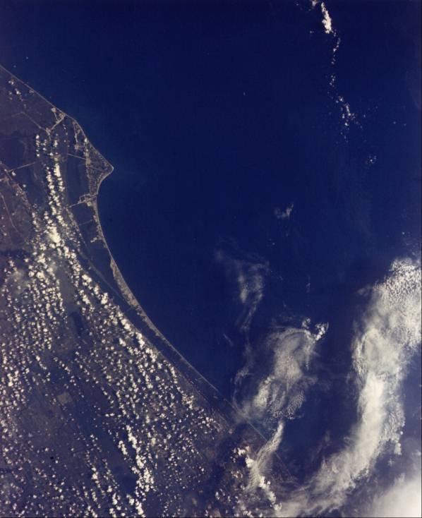
Florida’s Cape Canaveral juts into the Atlantic Ocean. The various launch pads of the John F. Kennedy Space Center get larger and more complex as you proceed northward along the coast. Launch Pad 5, where the first Mercury flight was launched, is difficult to see, while the giant Launch Complex 39 built for Apollo and also used by Skylab covers several square kilometers. Cumulus clouds form in long “streets” parallel to the coast. Manmade waterways can be traced by the spoil banks which show as small white dots along the right of way. (S65-45599; Gemini V.)Ethiopia’s Lakes Zwai, Langana, Hora Abyata, Koka, and Awusa show different colors. This is primarily due to water temperature differences resulting in each lake supporting different algae and other micromarine life. Spacephotography can permit a continual survey of the world’s water resources and quality. (S65-63162; Gemini VI.)The once mighty Colorado River separates the Mexican state of Baja California from Sonora at its mouth. It has been reduced to a sluggish, salty stream by removal of most of the water for irrigation or use by the cities of Southern California. Sediment flows can be traced in the Sea of Cortez (Gulf of California). The limits of the pre-water-use Hood plain can be easily delineated. Note that the geology is completely different in Baja California (left) from that of Sonora (right). The buff sands of the Grand Sonoran Desert lend color to this extraordinary photography and contrast with the block fault mountains of Baja California. Thus, the interface of meteorology, geology, and oceanography is seen in a veryremote area. (S65-34673; Gemini IV.)The geology of south central Iran stands out clearly just east of Shiraz. Two salt lakes, Tasik and Bakhtegan, show many shorelines due to changes in level caused by spring snow melt and occasional rain. The long ridges of the Zagros Mountains run from northwest to southeast. The ancient Persian city of Persepolis is at the upper left margin. (S65-45720; Gemini V.)Three hundred kilometers northeast of Chunking, China, the Yangtze River flows through a deep gorge. The structural geology causes a classic display a "trellis drainage" as streams flow in parallel valleys, eroding the softer rocks, leaving the harder rock as great linear ridges. (S65-45713; Gemini V.)This striking view of the Delta of the Nile, Suez Canal, and Sinai has become a classic space photo. Ancient Egyptian Pharaohs would tell their people that "in the autumn God will send the water down the Nile." With absolute regularity and beneath a cloudless sky, the Nile would spill over its banks and inundate this dark triangle. This was caused by rains thousands of kilometers away in Central Africa. The process would irrigate, fertilize, and clean the rich soils, generating a more than adequate food supply. Historically, nations with surplus food supplies are those that change the world. Nearly 40,000,000 people live in the 20,000-square-kilometer green triangle. (S65-34776; Gemini IV.)The Hadhramawt Plateau of South Yemen exhibits a complex dendritic drainage pattern and excellent examples of "stream piracy." Wadi Hadhramawt opens into the sand-filled Ramlat Sabatayn in the southwest corner of the Rub-al-Khali(The Empty Quarter), yet drainage is toward the sea. The southern coast of the Arabian Peninsula is at the upper portion of the photograph. (S65-34658; Gemini IV.)On rare occasions water flows in the Algerian Sahara. The Oued Saoura is viewed with flowing water after a rain. The area viewed is the southwest corner of the Grand Erg Occidental about 350 kilometers SSE of Colomb Bechar. The Oued Saoura flows southeast along the right edge of the photo; just off the lower right corner it passes through a water gap, reverses direction, and flows northwest into a salt marsh called the Sebcha Melah. (S65-63830; Gemini VII)The sharp contrast between the green irrigated Nile Delta and the arid Sahara can be clearly seen from 160 kilometers overhead. Canals, highways, railroads, towns, and villages can be located. The great city of Cairo is at the head of the delta. Just north of Cairo the Nile splits, forming the Rosetta and Damietta branches. South of Cairo, agriculture is confined to the straight, narrow, long valley to the first cataract at Aswan. Photos from space can assist in land use studies. (S65-45778; Gemini V.)A dark arrow points westward across Texas’ Edwards Plateau. Its tip is near Rankin, just east of the Pecos River, and widens to the east. It was caused by a widening rain shower several days before which brought moisture to this desert landscape and caused the plants to grow. The light area to the right is the Llano Estacado (Staked Plains) and the Permian Basin oil fields.The dark streams make up the Concho River system west of San Angelo. Photography from space can be a valuable tool in the field of agriculture. Continual monitoring from spacecraft can accurately tell the world such information as water availability, crop disease and insect infestation locations, crop identification and projected yields,grazing conditions, and much more information necessary to improve food supply for expanding populations. (S65-34704; Gemini IV.)