Chapter 5: Craters
![Figure 96. Location of photographs in this chapter; numbers correspond to figure numbers. [Base map courtesy of the National Geographic Society]](./images/p104a.jpg)
![Figure 96. Location of photographs in this chapter; numbers correspond to figure numbers. [Base map courtesy of the National Geographic Society]](./images/p104b.jpg)
The most common process that affects the lunar surface is impact cratering. Craters range in size from those that are 1000 km across and can be seen with the naked eye from Earth to those that are so tiny that the most powerful microscopes are required to study them. These tiny craters are abundant on the smallest grains in samples brought back from the Moon. In general, the size of the largest craters that pepper a particular surface is a measure of the age of that surface. Younger areas contain small craters; very old areas are covered with very large craters.
In addition to giving a measure of the age of the lunar surface, craters provide information about other processes that affect the Moon. Study of the shape of the craters and the distribution of the material ejected from the craters gives information on the nature of the projectile, its energy, and direction of impact. In turn, this information tells what kind of object caused the crater-whether it was a low density cometlike object or a high density asteroid.
Study of the material ejected from craters provides data on the temperature and pressures caused by the impact. Changes in the chemistry of the materials and in the mineral form-called impact metamorphism also give clues to the nature of the projectiles. Of course, if pieces of the impacting object can be found, a direct determination can be made.
To better understand lunar impact structures, studies have been made of natural impact craters on the Earth as well as of manmade craters. Detailed studies of the craters made by explosives, ballistic missile impact, or by firing projectiles from high velocity guns at rock targets have resulted in some understanding of the process by which craters are made. As the high-velocity projectiles enter the target, a compressional shock wave spreads away from the entrance point, followed by a rarefaction wave that throws most of the ejecta out of the crater. Finally, the floor of the crater rebounds, forming the central peak. Three kinds of deposits can be found around a crater. One kind is the lines of ejecta thrown out along ballistic paths that are lines of secondary craters. On the Moon, these form the bright rays that extend for 10 to 30 crater diameters. A second type occurs when a continuous blanket of ejecta extends outward one to two crater diameters: such a covering formed by movement of the ejected material along the surface is the so-called "base surge." This flowing material may form ridges and dunes that vary according to the velocity of the flow and the preexisting shape of the surface. Molten ejecta can flow down the interior walls of an old crater in its path and form a puddle on the crater floor or flow down the outside sloping rim of the crater. The third type of deposit is the lines of ejecta radiating from the central peak. These materials are the last to be ejected from the crater.
Craters fall into three groups. First, there are primary craters, which are generally randomly placed. Occasionally cosmic debris has struck the Earth in long lines, forming features such as the Campo de Cielo line of meteorite craters in South America; such an alinement of primary craters could occur on the Moon. Second, there are radiating and looped patterns of smaller craters surrounding the larger primary impact crater. These secondary craters in turn may have fans of ejecta thrown out from them in the direction away from the primary crater. Third, there are craters of internal (volcanic) origin. These have a different form, are often alined along fractures, and have ejecta blankets of different style and form from those of impact craters. Impacted ejecta has many blocks and forms very hummocky deposits; volcanic ejecta is fine "rained and usually smooth. - H.M.
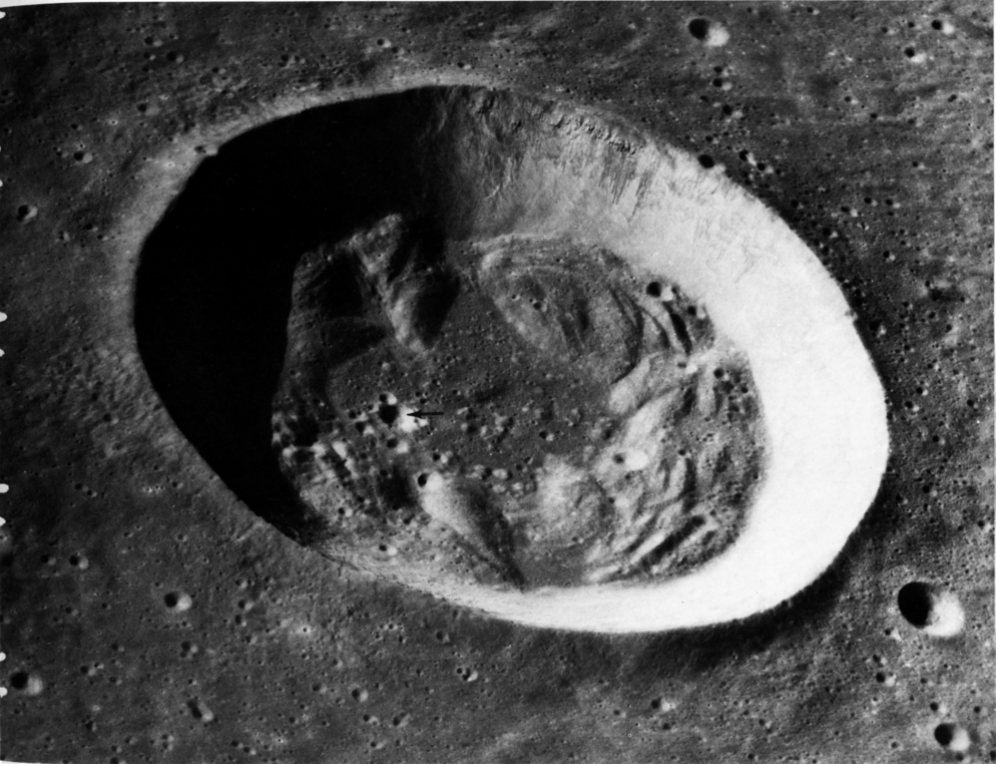
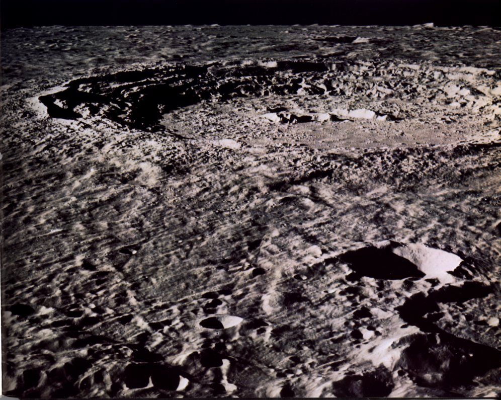
AS15-0293 (M)
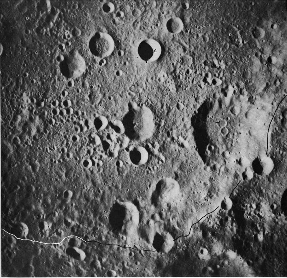
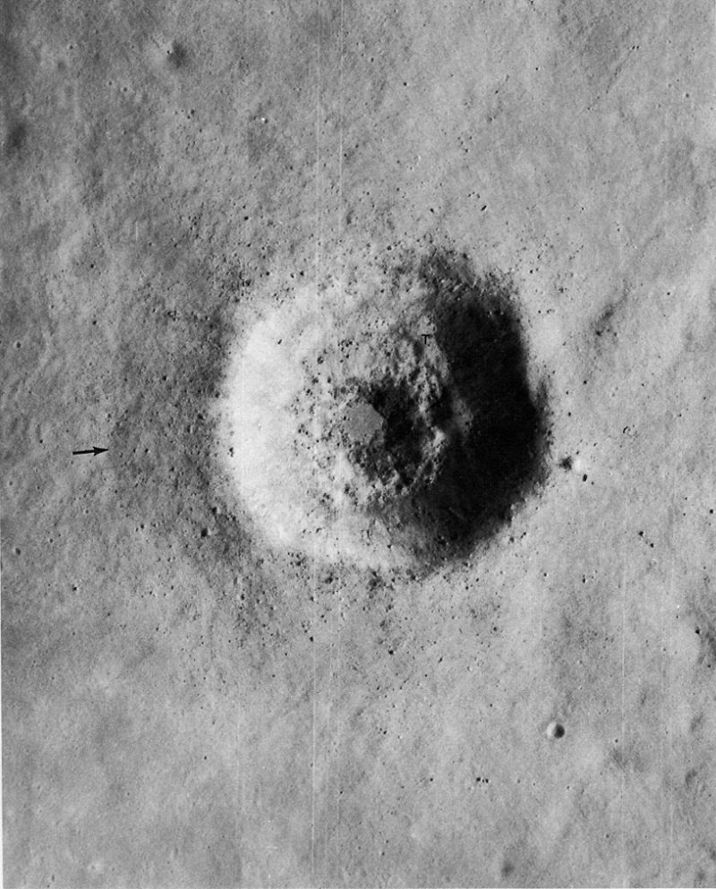
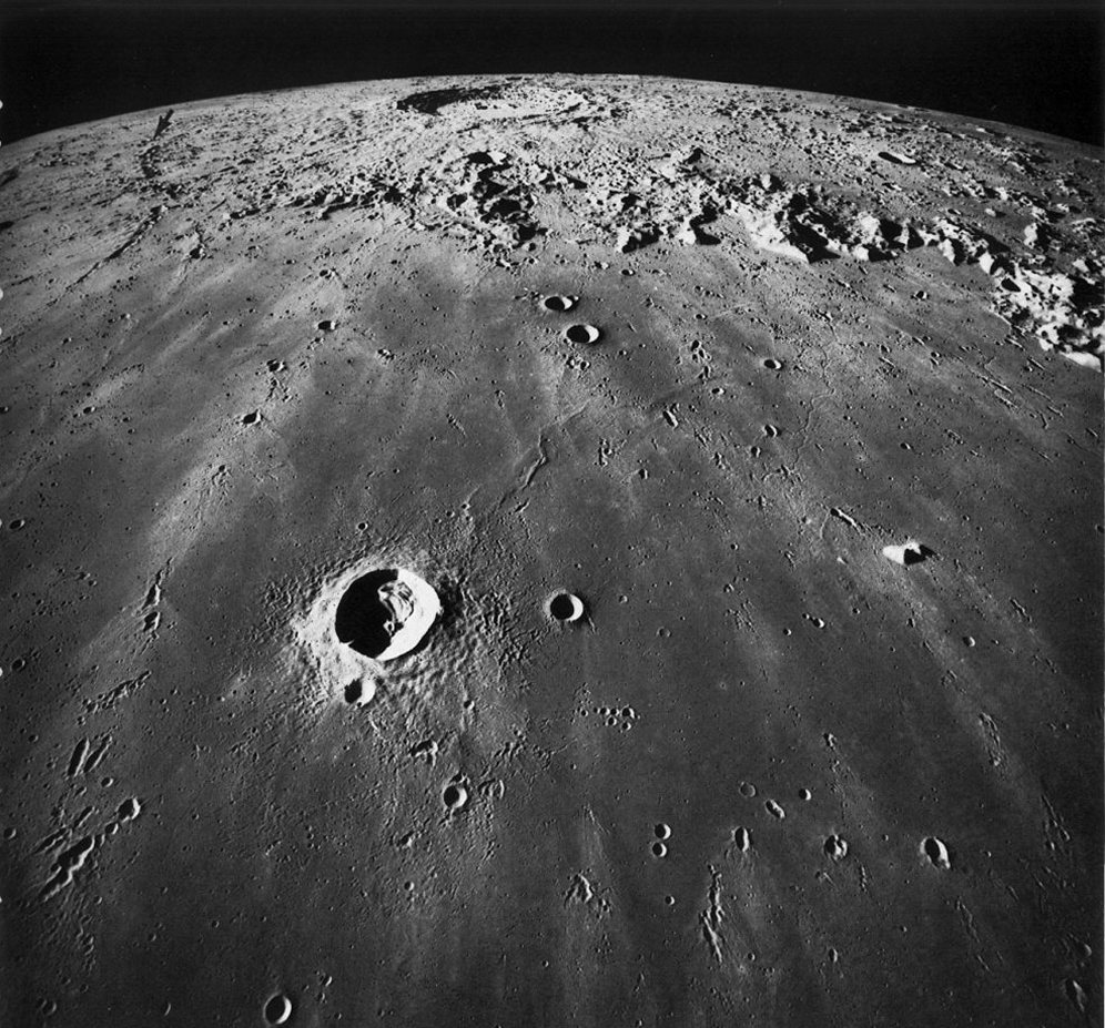
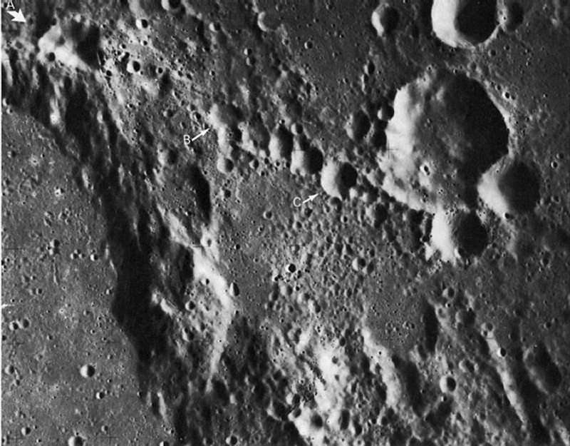
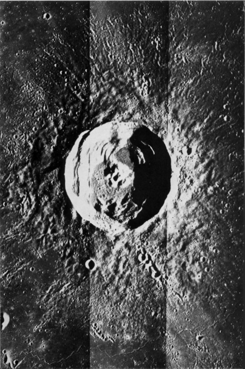
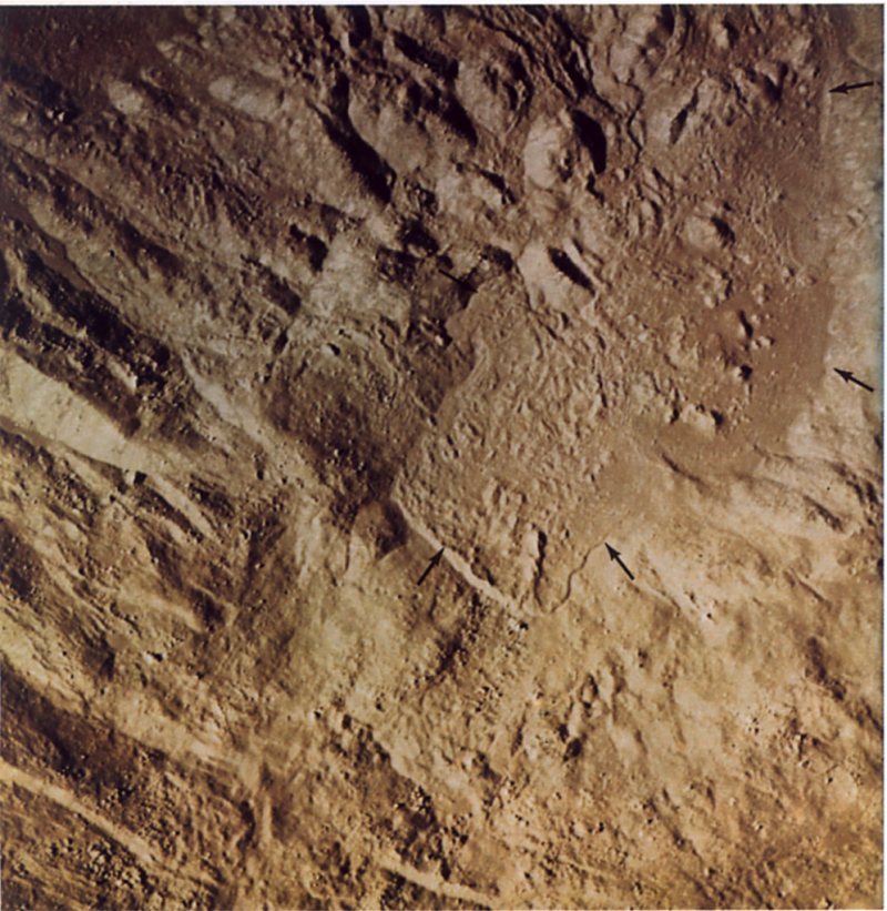
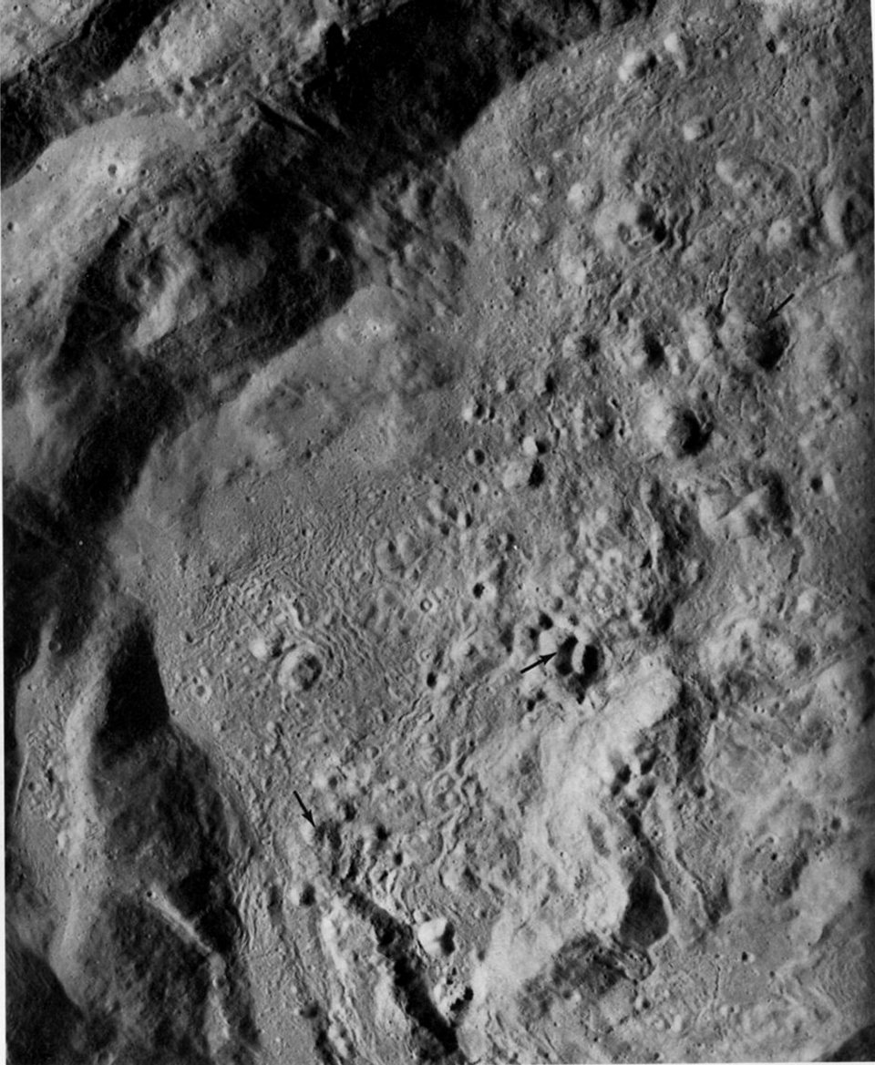
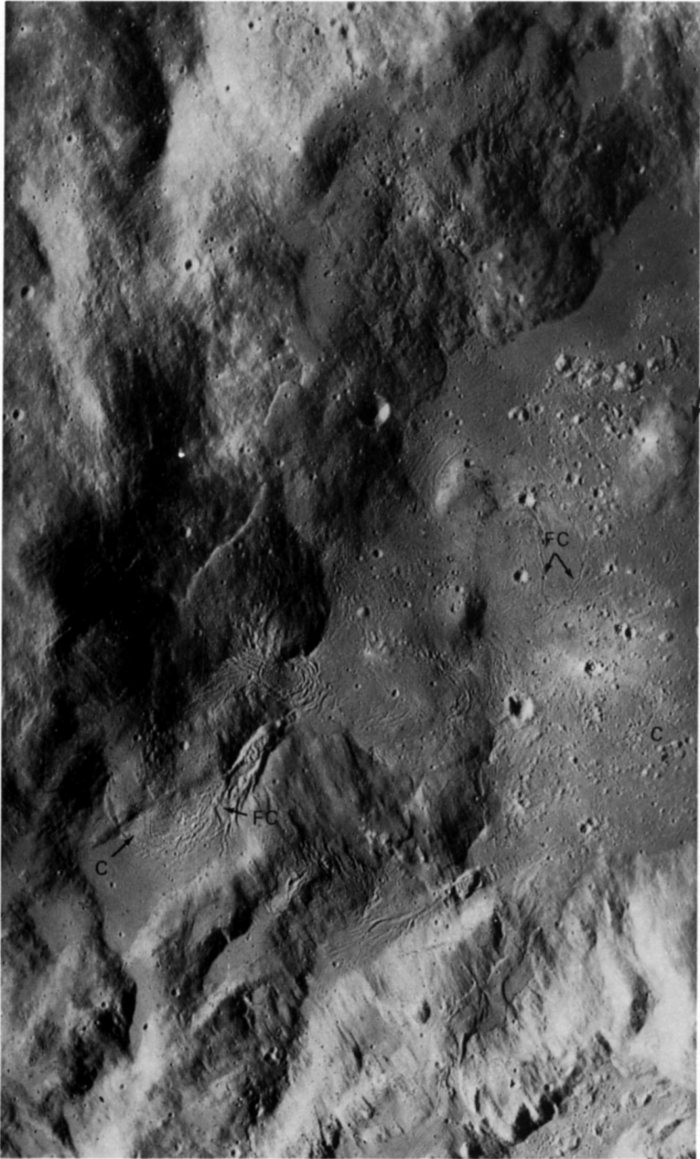
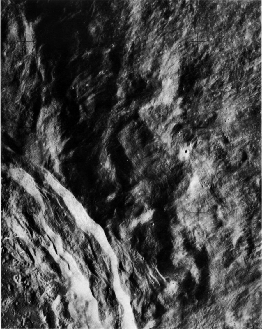
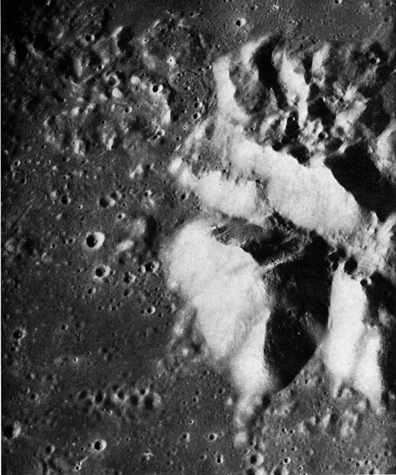
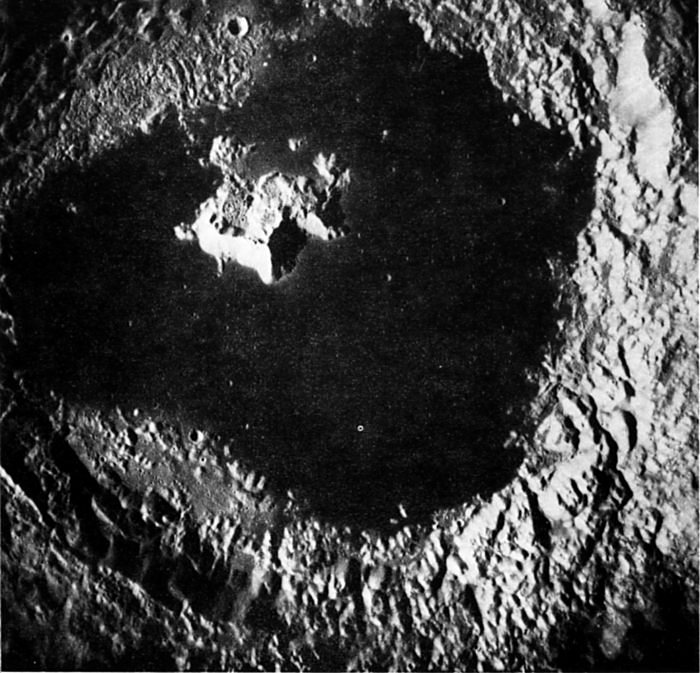
FIGURE 97. - Craters, craters, craters! The far side, even more than the near, presents a tortured record of the bombardment suffered by the Moon throughout its history. This scene exemplifies the relentless attack of impacting objects from space and from the lunar surface that has characterized most of lunar history.
The craters in this far-side area come in various shapes, sizes, and degrees of degradation attesting to a variety of formative processes, energies of formation, and ages. Each individual circular crater was probably produced by the impact of a body from interplanetary space- the larger the crater, the higher the energy; that is, the larger the body, or the greater its velocity upon impact. The first and largest such impact erased all earlier features and produced the crater that fills most of the scene, Gagarin, 265 km in diameter (rim crest outlined). A series of smaller craters followed, starting with crater A (46 km), itself heavily cratered, and ending with the sharp funnel-shaped craters and crater C(14 km). The young age of crater C is demonstrated by the sharpness of its rim crest and its halo of extremely fine, fresh ejecta and secondary craters. During the rain of objects from space, clots of lunar material ejected from impact craters outside this area landed here to form irregular secondary craters. Examples (D) are the elongate partly filled crater near the upper right corner and the elongate but deeper craters in the upper left. Conceivably, however, some irregular craters were formed by volcanism, a process that at one time was widely believed to be the cause of most irregular craters on the Moon. At some time late in the history of the region, an even more distant impact hurled a loose cluster of debris to form the group of sharp, circular (high-energy) craters in the left center of the picture.
In this section of the book other primary and secondary craters will be illustrated as will some possible volcanic craters and some craters whose properties are too obscured to reveal their origin-like crater B and its twin Iying inside the older crater A in this picture. - D.E.W.
AS17-150-23102 (H)
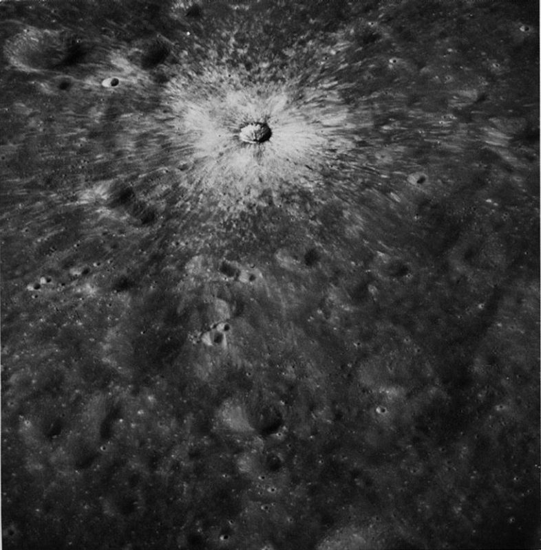
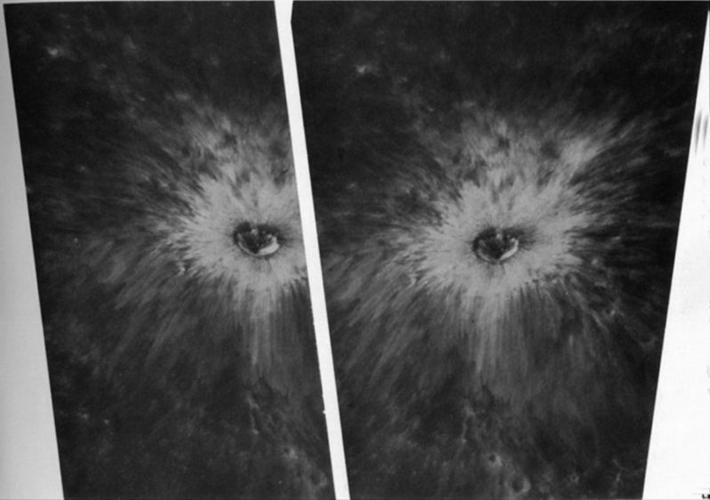
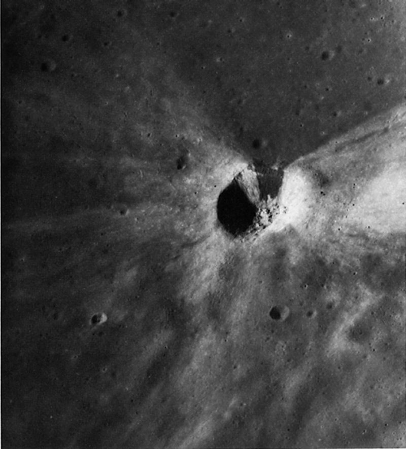
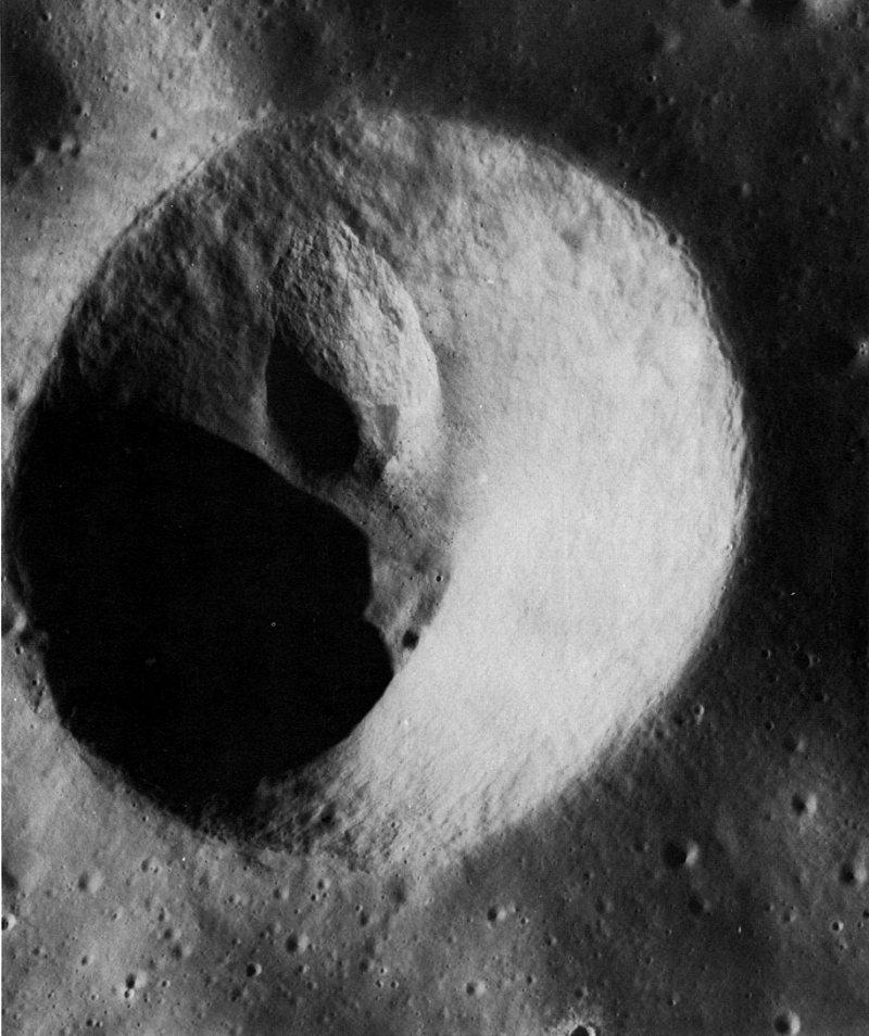
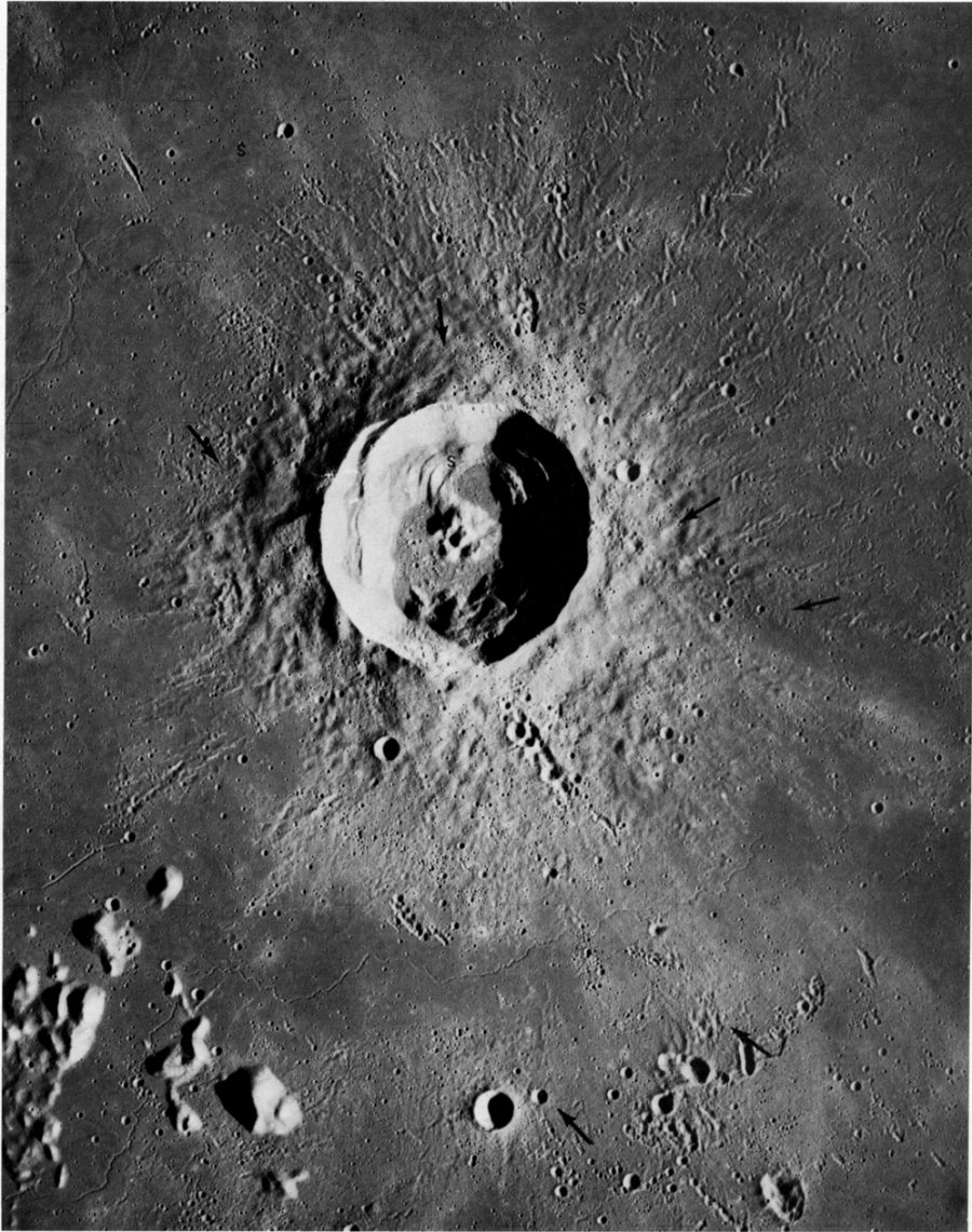
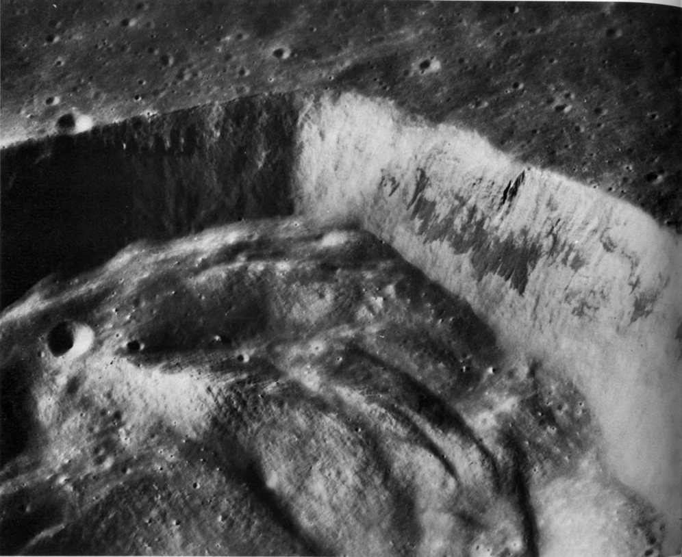
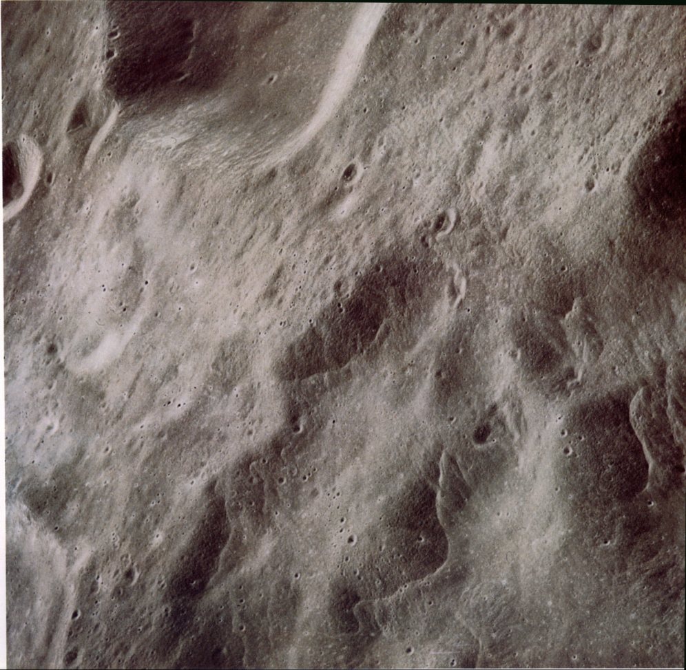
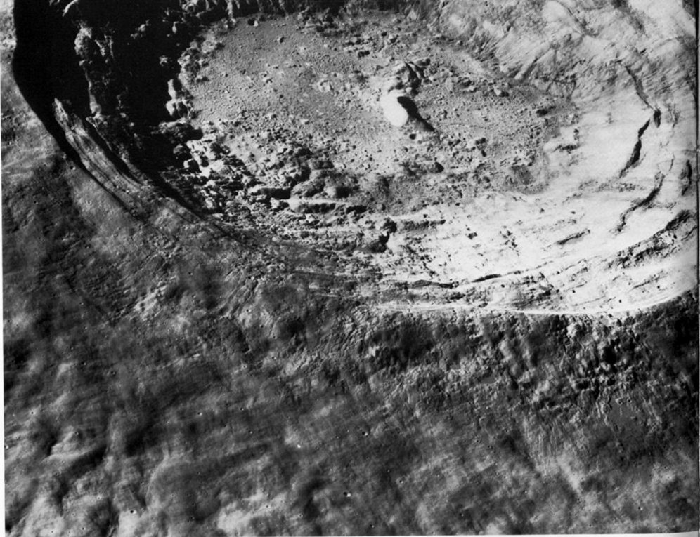
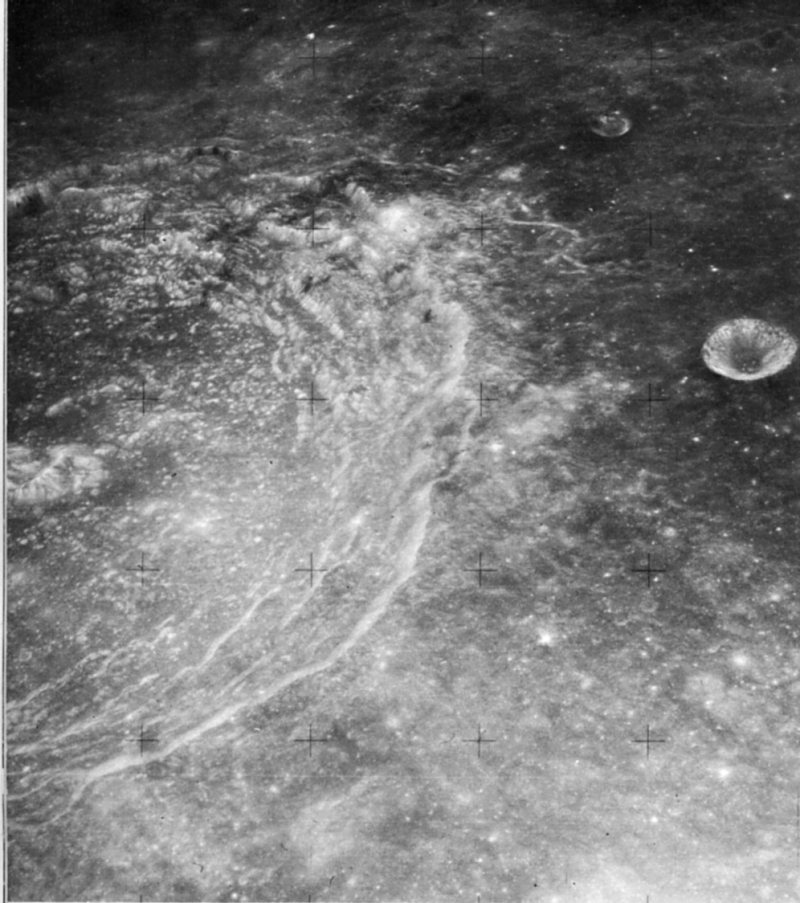
FIGURE 98. - This slightly oblique Hasselblad photograph, taken from Apollo 17, is an excellent view of a small, very young impact crater. Slightly less than 3 km in diameter, it is located on the west flank of the large crater Gagarin on the lunar far side. The youthfulness of this small crater is illustrated by its sharply defined rim crest; by its bright continuous blanket of ejecta extending outward for 1 to 2 crater diameters; and, most particularly, by its exceptionally welldeveloped radial pattern of bright rays. The rays consist of narrow, diffuse streaks and shorter bright spots. They are formed when ejected material from the impact site is redeposited as projectiles in the form of discrete blocks and clusters of disaggregated debris. The brightening is probably caused by the shock effects on the rock that was excavated from the impact site and deposited onto the older, darker surface materials. - F.E.- B.
AS15-0102 (M)
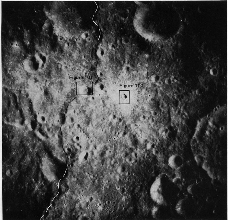
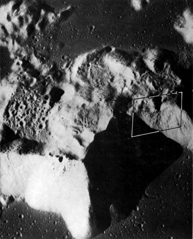
FIGURE 99. - This is the same small crater as appears in figure 98, oriented in the same way, but shown in a vertical view taken with the panoramic camera on Apollo 15. The western rim of Gagarin is marked by a dashed line. For easier comparison with figure 98, north is at the bottom. The Sun angle is very nearly the same in both pictures, but the oblique view recorded by the Hasselblad camera is certainly more spectacular. However, in many respects this vertical view is better suited for detailed study. The symmetries of the crater proper, its ejecta blanket, and its pattern of filamentous rays are even more apparent. Some of the rays extend to the edge of the frame, a maximum distance of slightly more than 50 km, or about 15 times the diameter of the crater. Figures 100 and 101 are enlargements of other photographs of the small areas indicated by rectangles. - G.W.C.
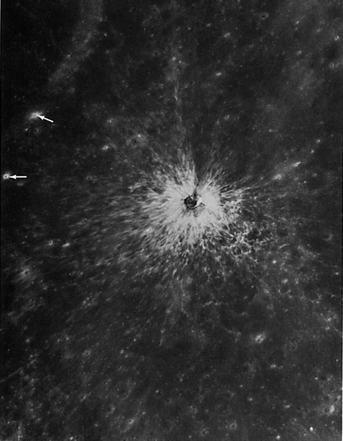
AS15-8936 (P)
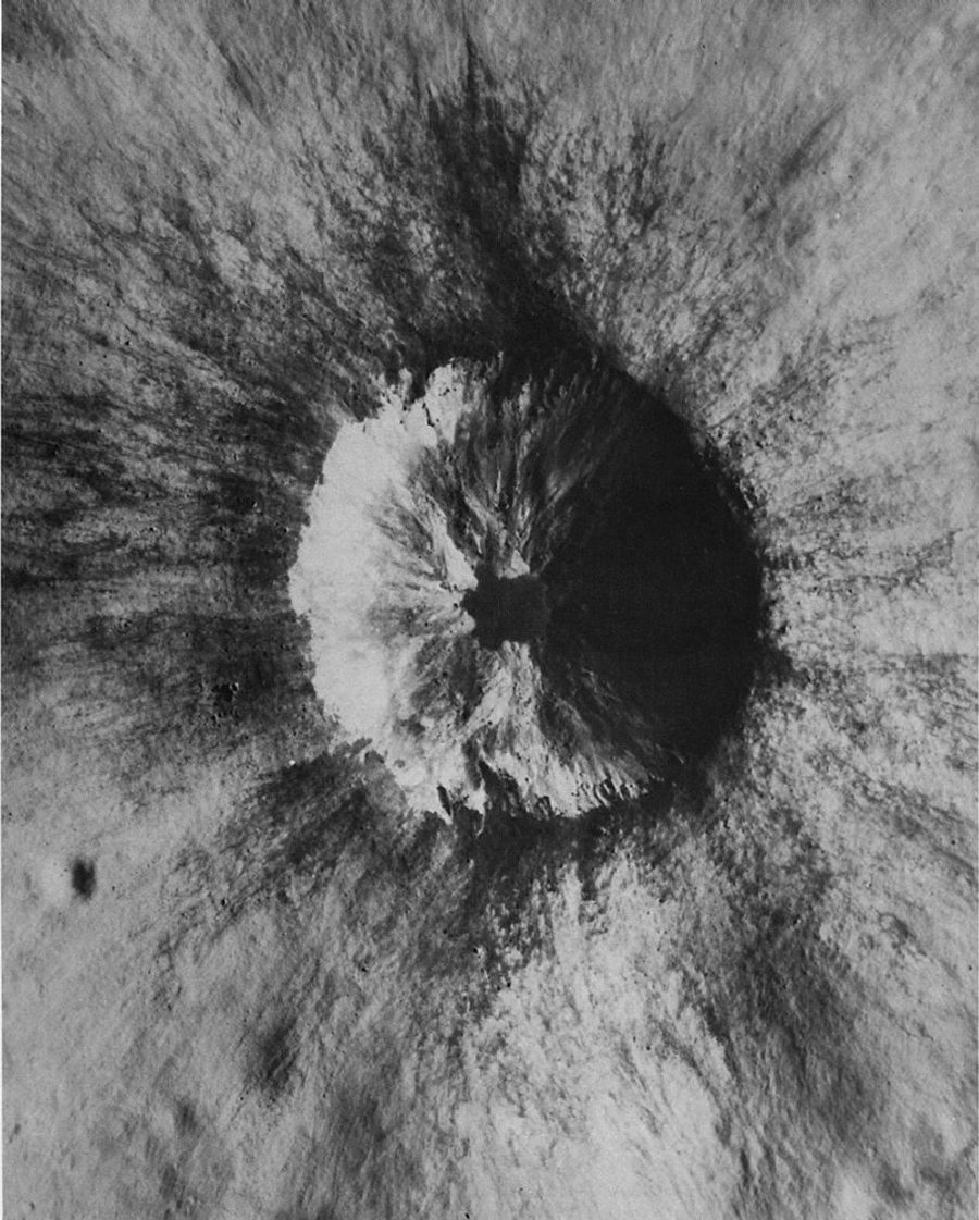
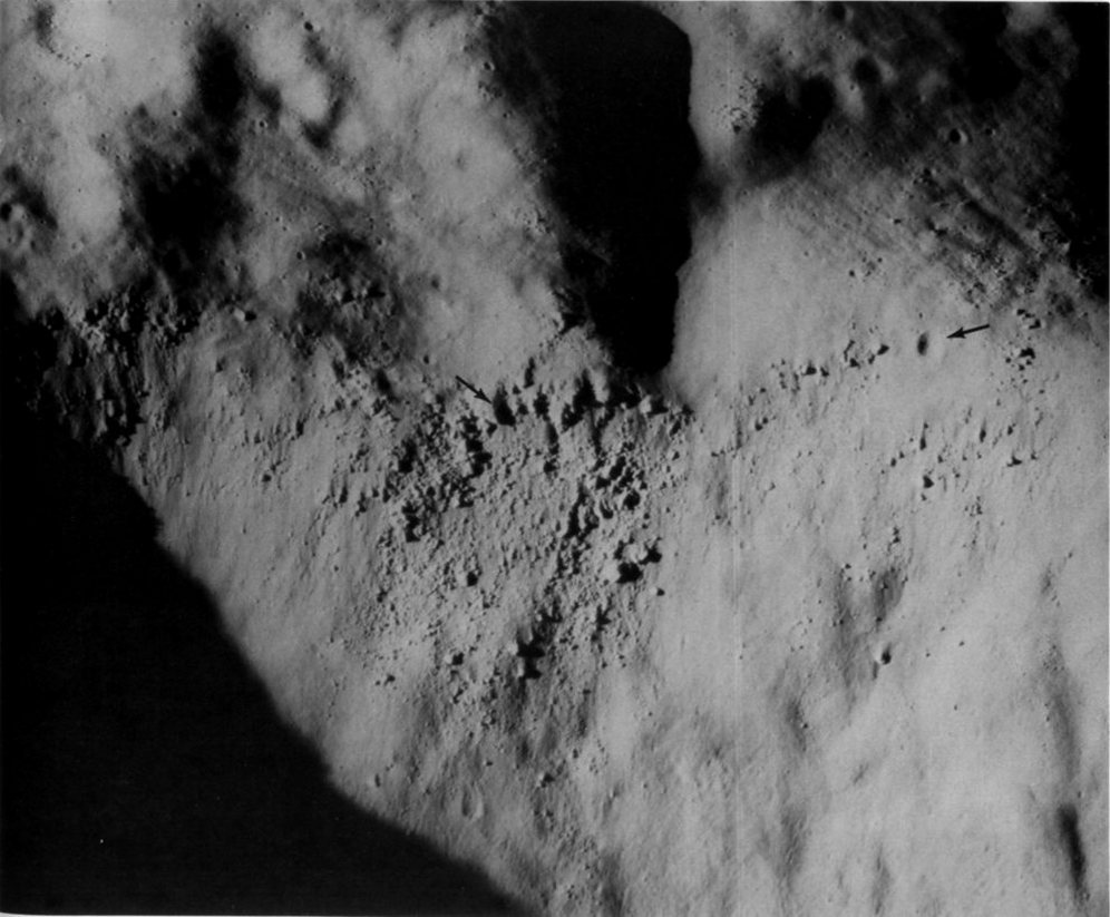
FIGURE 100. - This is an enlargement of a small part of a panoramic camera frame showing the same crater in much more detail. The high resolution inherent in the camera system shows that the bright radially grooved ejecta contains many large blocks near the rim and that dark fine-textured material overlies the light coarse ejecta. Notice how the dark material occupies depressions on the rim, slumps down the walls, and forms a smooth-surfaced pool at the bottom of the crater. Also visible are ridges of bedrock in the upper walls and lobes of light-colored debris extending down onto the floor. Most aspects of the crater indicate that it was formed by impact. The dark material probably was penetrated at depth and ejected late in the explosive stage to accumulate in the vicinity of the rim. A volcanic origin for the dark material is possible but less likely. - B.K.L
AS15-8937 (P)
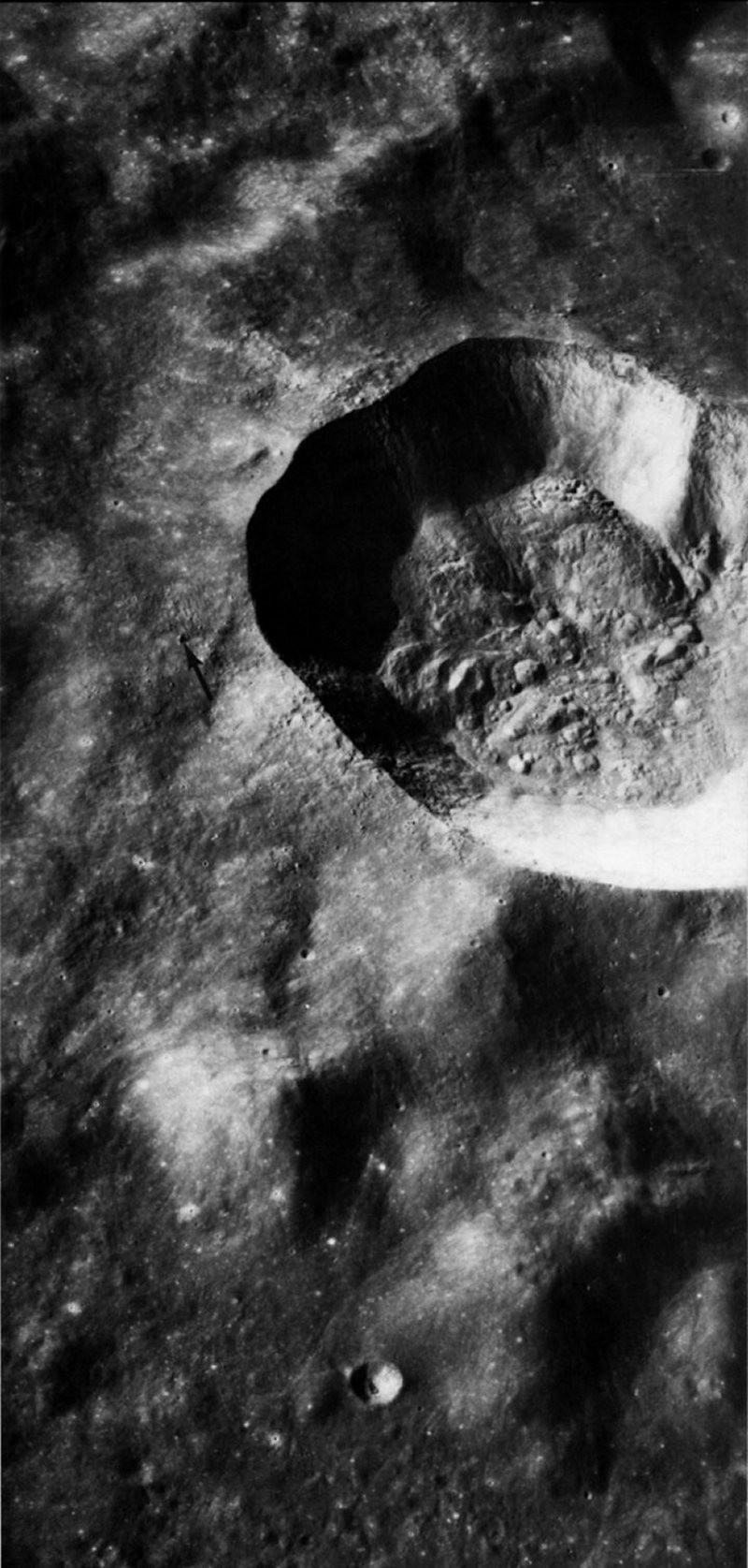
FIGURE 101. - Ray material from the fresh crater described in figures 98 to 100 covers an old, degraded 12-km crater located a few tens of kilometers farther east (fig. 99). The light linear streaks and pointed markings are the rays from the fresh crater. In this picture the light material overlies dark regolith. Fine linear depressions (A) in the light patches are chains of secondary impact craters. They are associated with most of the light patches, and in some places (as at B), lie at their origin, thus showing that much of the ray material may be composed of local material disturbed by secondary impacts. In some places no such association is obvious, and the rays may consist of material ejected from the primary crater. - B.K.L.
AS15-9348 (P)
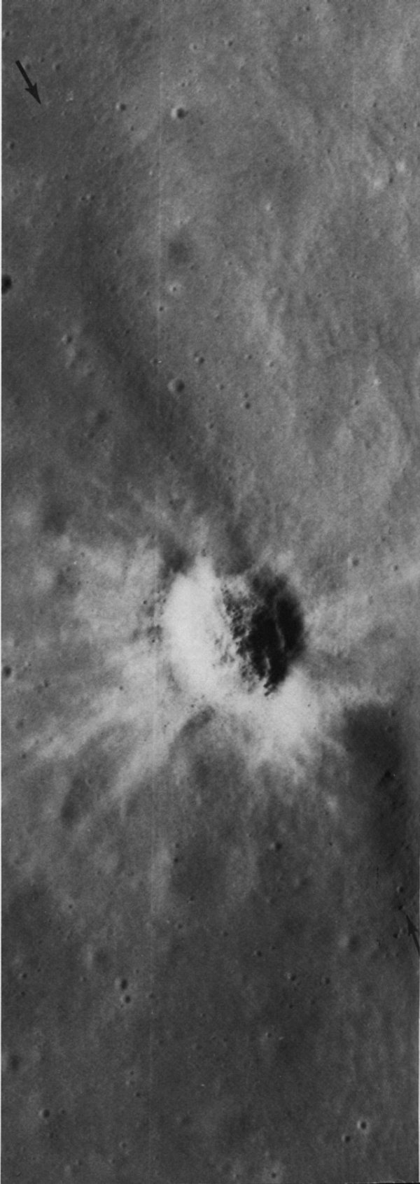
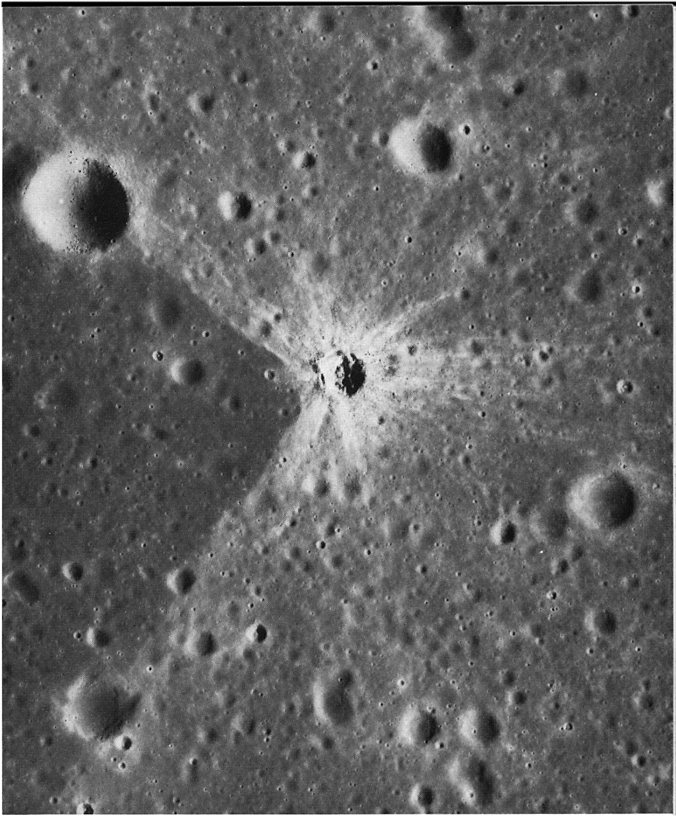
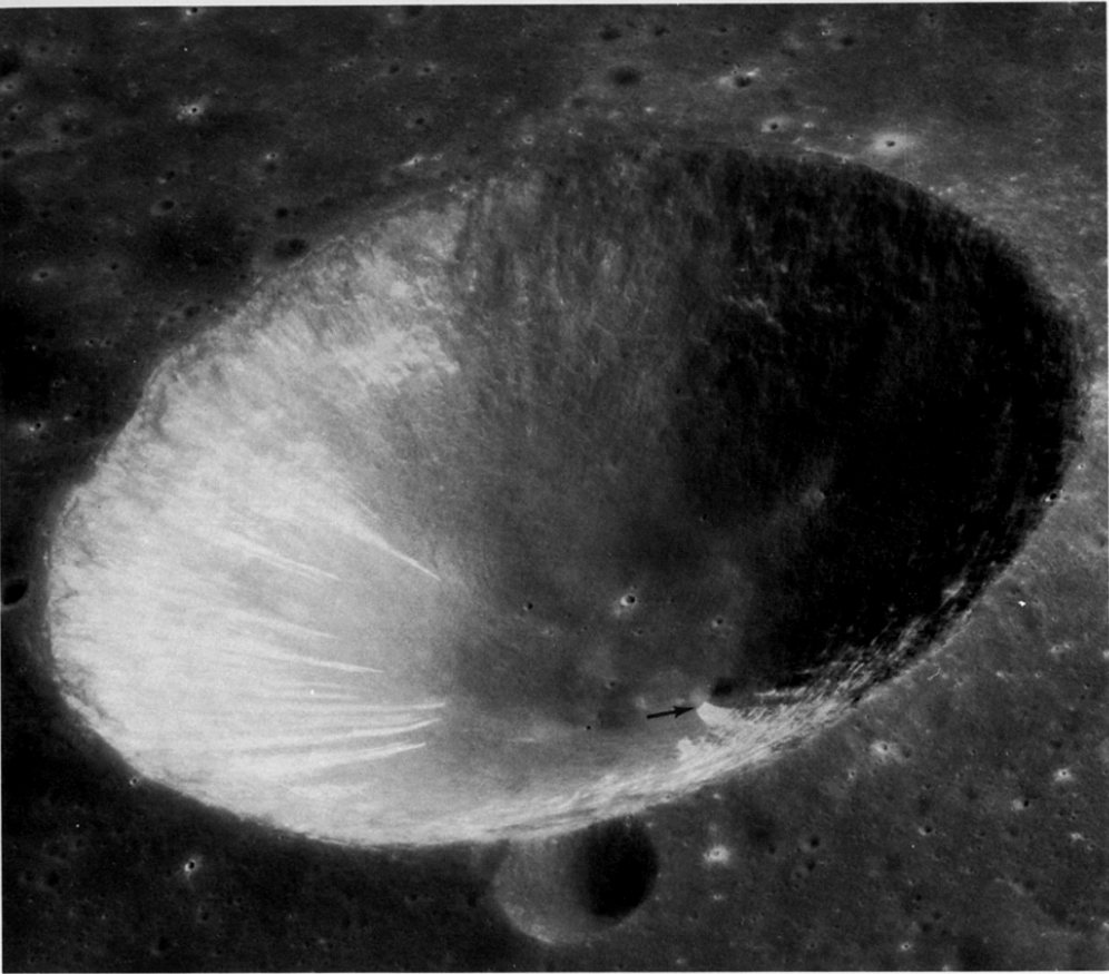
FIGURE 102. - The characteristics of an extremely youthful small crater are illustrated in this Apollo 15 panoramic camera photograph of the crater Linne as viewed from the south. The 4-km-diameter crater is located in the western part of Mare Serenitatis. The rim of the crater slopes steeply up from the mare surface, and the rim crest is sharp and even. Boulders are abundant on and near the rim. Concentric dunelike features occupy the inner part of the ejecta blanket and, with increasing distance from the crater, give way to irregular arcuate clusters of satellitic craters. A more subtle radial pattern in the ejecta can be seen where the Sun's rays shine across it, to the north and south of the crater. The bright ejecta blanket and ray pattern displayed here are typical of very youthful craters of all sizes. - M.C.M.

AS16-4136 (P)
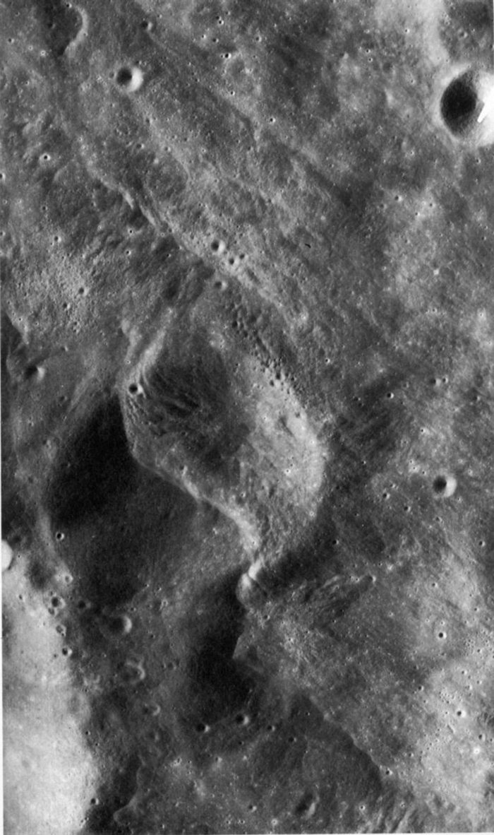
FIGURE 103. - This view looks southward near Mandel'shtam on the lunar far side. Most young lunar craters wider than about 40 km have flows on their rims that resemble lava flows or mud flows on Earth. The unnamed crater near the top is about 14 km wide and was recognized by H. J. Moore (1972) as being the smallest crater known to have such flows. Flows in the middle of the picture surged downhill off the high rim of the crater making lobes and tongues and leaving behind drained channels with levees. In the area to the right of the crater, enlarged in figure 104, are some thin lobate flows that apparently rode over small hills, as if these flows were propelled outward from the crater with sufficient velocity to climb the hills. Ejecta deposits farther than about 1 km from the rim are radially lineated and are smoother than the ground immediately surrounding the crater. The crisp, blocky zone around the crater is typical of many fresh craters. - K.A.H.

AS16-4136 (P)
FIGURE 104. - This enlarged view of part of figure 103 shows some of the smooth flows that originate near the crest of the crater rim at the left side of photograph. Arrows point to the lower ends of two flows. The origin of the flow material is controversial. It was probably molten material generated by shock-wave compression of lunar rocks and ejected at relatively low velocities during the late stages of the formation of the impact crater; or it may have resulted from the flow of rock debris mixed with a fluidizing agent such as gas or water; or it may have been volcanically generated lava. - H.J.M.
AS16-4558 (P)
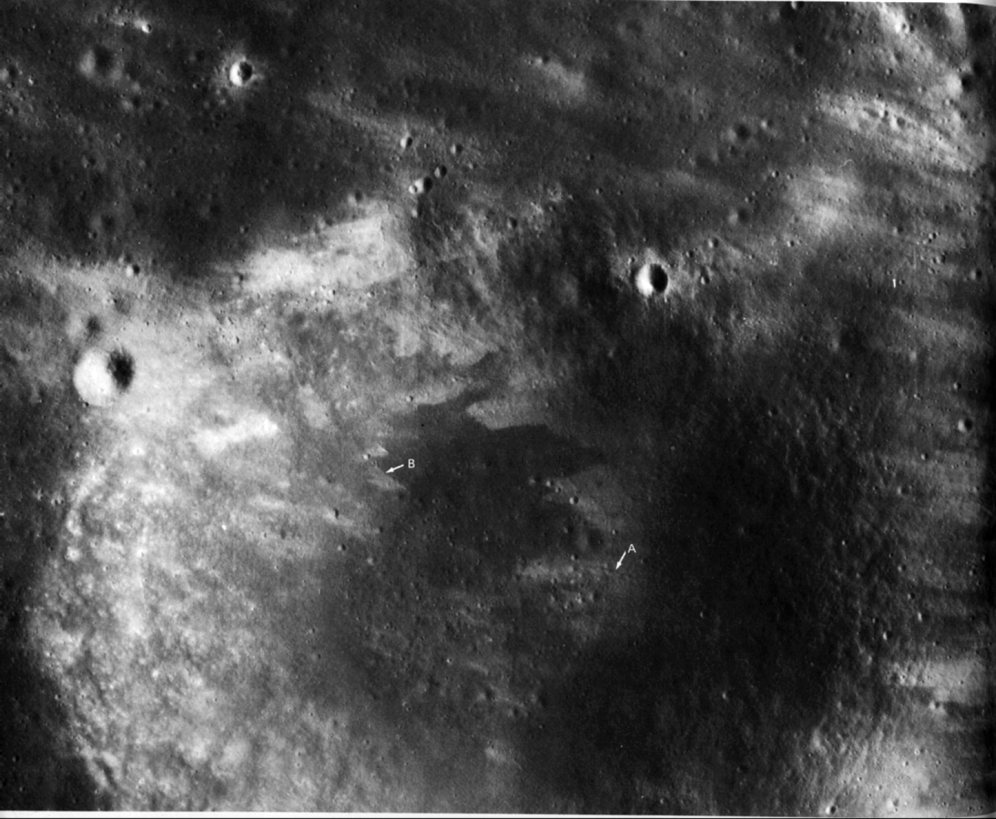
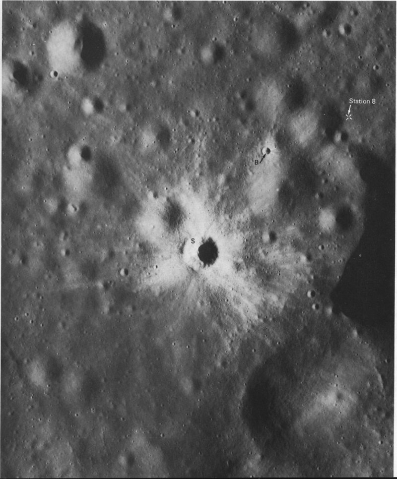
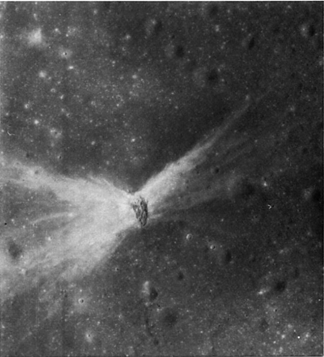
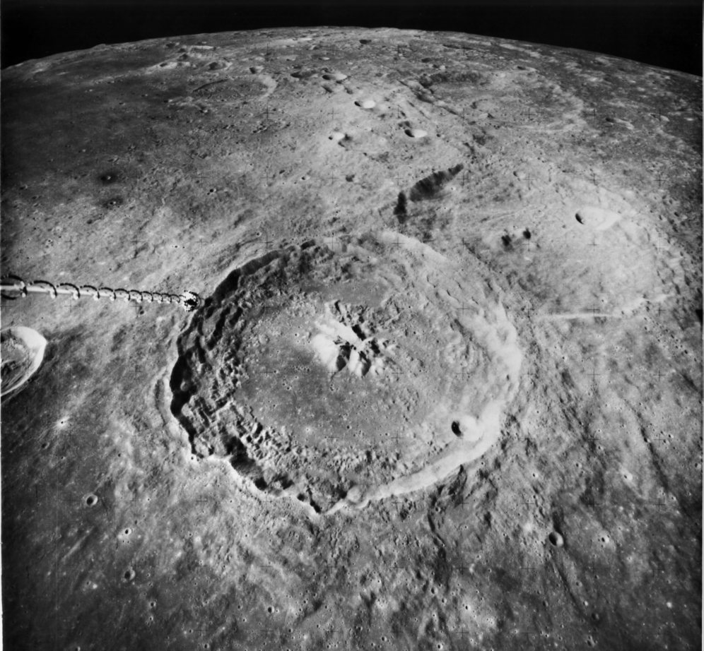
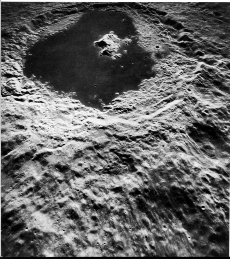
FIGURE 105. - The two bright-rayed craters in this picture have been examined more closely from the lunar surface than those illustrated earlier in this chapter. The larger one, South Ray (5), is located 6.2 km southwest of the Apollo 16 landing point, indicated by an arrow at the top edge. At sampling station 8, 3.4 km from the edge of South Ray, astronauts John Young and Charles Duke sampled some rocks from South Ray that had been deposited as ejecta along one of its numerous rays. Studies of these rocks indicate that South Ray formed about 2.5 million years ago bringing rocks 3.8 billion years old to the surface. The impact that created South Ray crater occurred when Australopithecus lived in Africa-well before contemporary man evolved. The much smaller rayed crater is Baby Ray (B). Its rim crest is much sharper than South Ray's and its rays overlie those of South Ray. Consequently it is younger, possibly having formed within modern man's time span. - H.J.M.
AS17-1769 (P)
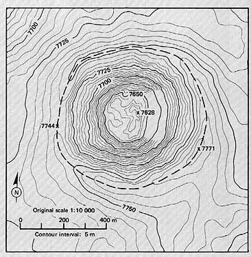
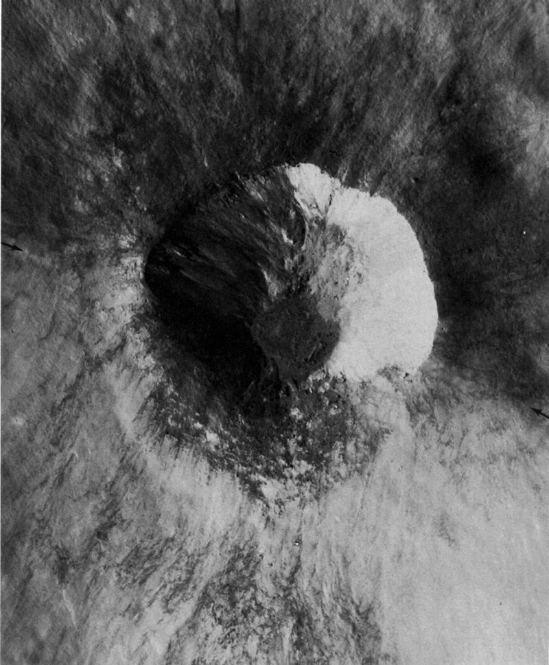
FIGURE 106. - Another view of the crater South Ray. This detailed topographic map was prepared under the supervision of S. S. C. Wu of the U.S. Geological Survey by photogrammetric techniques. Prepared from a stereo pair of panoramic camera photographs, it is one of the largest scale maps ever done with Apollo orbital images. The area shown here is a small part of a map that was used for compiling geologic data from the Apollo 16 mission. Dashed lines have been added to the original map to show the crest of South Ray's rim. From this type of topographic representation, the width, depth, slope of the walls, and other parameters can be measured. For example, the maximum depth of the crater, measured from the high point on the rim (7771 m) to the low point in the floor (7628 m), is 143 m. - G.W.C.
AS17-1764 (P)
FIGURE 107. - The bright rays around this fresh 1.5-km crater on the Moon's far side show the effects of ejecta thrown out on rugged highlands. The Sun is nearly overhead; therefore, the relief is not conspicuous. When viewed stereoscopically, the crater is seen to be perched on the top of a high bluff that slopes steeply toward the foreground. On top of the bluff, the ray pattern resembles splashes, but on the steep slope the rays cascade in lobes like streamers in a waterfall. The lobes may be avalanches triggered by ejecta striking down on the slope. Dark material on the rim and wall of the crater and pooled in the crater floor may be glassy rocks melted by the impact (Note: This pair demonstrates the problem caused when areas near the ends of unrectified panoramic camera frames are used for stereoscopic viewing. Geometric distortion makes it impossible to view all the overlapped area stereoscopically.) - K.A.H.
AS15-9721 (P)
FIGURE 108. - Another fine example of a small crater with extensive bright rays. It presumably was formed by meteoroid impact. Both light and dark rocks are visible in the walls, indicating that more than one layer of rock was penetrated. Rays formed by secondary craters, blocks, and pulverized ejecta extend more than 13 crater diameters beyond the crater proper. The marked irregularity of the pattern southeast of the crater probably was caused by topographic irregularities that deflected the radially outward movement of the ejecta. Arrows indicate smaller bright- rayed craters. - M.W.
AS15-9301 (P)
FIGURE 109. - The configuration of this small crater has been affected by the topography of the impact site. It is located near the eastern edge of Mare Serenitatis, north of the Apollo 17 landing area. The body that excavated the crater impacted at the foot of a westward-facing fault scarp that bounds one side of a graben, or fault trough. The fault scarp is coincident with the diffuse narrow band of shadow extending between the arrows; the area west of the scarp, the floor of the graben, is noticeably lower than the area to the east. The flow of ejected debris toward the east was apparently blocked by the scarp, resulting in an abbreviated bright halo and ray pattern in that direction. - G.G.S.
AS16-121-19407 (H)
FIGURE 110. - An oblique view looking northwest at part of the wall of the crater Lobachevsky on the lunar far side. It shows a small crater on Lobachevsky's wall with unusual streaks of dark material that appear to have originated from the lower rim of the structure and to have moved down toward the floor of Lobachevsky. This feature was first noticed by T. K. Mattingly, the Apollo 16 CMP, who described the darker streaks as probable lava flows (Mattingly, El-Baz, and Laidley, 1972). However, the streaks can also be explained by the downslope movement of dark fragmental debris excavated from Lobachevsky's wall by the small crater. Closer to the lower border of the photograph is a bright area extending across Lobachevsky's rim. This area and other sinuous light-colored markings in the upper half of the photograph are on the periphery of an enormous field of light-colored swirls in this part of the far side (El-Baz, 1972a). The origin of the swirls is not well understood. - F.E.- B.
AS16-4511 (P)
FIGURE 111. - For easier viewing, this picture is oriented with north at the bottom of the page. It shows the striking bilateral symmetry of the rays of a small (2-km diameter) crater in the floor of the large crater Daguerre in Mare Nectaris. Continuous areas and narrow filaments of light-gray ejecta extend from the crater across the dark mare surface through 270°, but are entirely absent in the southern 90° sector. Within the crater, dark material occurs on the southern crater wall while the remaining walls are bright. (The reader may wonder about the material whose reflectivity cannot be observed because it lies in shadow on the east wall of this crater. Until the area is observed under high Sun conditions, we are forced to make the simplifying assumption that it is bright because most of the materials visible elsewhere in the walls are bright.) This crater probably resulted from the impact of a projectile traveling from south to north along an oblique trajectory. Its pattern of ejecta distribution is similar to that of small craters produced by the impact of missiles along oblique trajectories at the White Sands Missile Range, N. Mex. Some observers postulate that the dark material is a talus deposit of mare material that has fallen into the crater. - H.J.M.
Another geological explanation is that the unusual pattern may be due to an intrinsic characteristic of the local terrain, probably an abrupt lateral change in the composition of the bedrock within the area that was excavated. F.E.- B.
AS15-9337 (P)
FIGURE 112. - This small young crater has an incomplete ray pattern. It is located in central Mare Serenitatis. The small raised features on the flanks of the crater are blocks of ejected bedrock, probably mare basalt. The largest is about 30 m across. In this picture, where sunlight is from the east (right), raised features appear as bright spots casting a shadow to the west. Note the relative scarcity of blocks on the side lacking rays. The absence of rayed ejecta and of discrete blocks to the west suggest that the impacting body was traveling from west to east along an oblique trajectory. The roughly concentric ledges in the rayed crater result from the interaction of shock and stress waves with the layered substrata. - H.J.M.
AS15-9254 (P)
FIGURE 113. - This elliptical crater is 1 km long with an unusual, winglike pattern of rays. This ejecta pattern is similar to those around some small experimental impact craters produced by missiles traveling along low-angle trajectories at White Sands Missile Range, N. Mex. From the shape of the crater and the distribution of the rays, it is difficult to tell whether the meteoroid was traveling from north to south or south to north. The higher albedo (brightness) of the north wall and the concentration of high albedo ejecta on the northwest and northeast flanks suggest that it traveled from south to north. - H.J.M.

AS17-2744 (P)
FIGURE 114. - This is an oblique view of another crater that probably was formed by a meteoroid following a relatively low-angle trajectory. This crater, 4 km in diameter, is located in the highlands east of Mare Serenitatis. Compared to the crater just described (see fig. 1 13), this one is less elliptical and its bilobate ray pattern is much less pronounced. The differences may be attributed to a higher trajectory angle of the impacting body that formed this crater as it struck the surface. H. J. Moore (1976), in his study of craters formed by impacting missiles at White Sands Missile Range, recognized a characteristic asymmetric profile along the axis of trajectory for craters formed in this manner. The wall beneath the missile trajectory is typically less steep than the opposite or down-trajectory wall, and its rim crest is lower and more rounded. These observations, when applied to the lunar crater in this photograph, indicate that the impacting body was traveling toward the east when it struck the Moon. - H.M.
![FIGURE 115 [above & below]. - Messier (1) and Messier A (2) are a pair of unusual craters in northwestern Mare Fecunditatis.](./images/hrp121a.jpg)
AS15-2405 (M)
![FIGURE 115 [above & below]. - Messier (1) and Messier A (2) are a pair of unusual craters in northwestern Mare Fecunditatis.](./images/hrp121b.jpg)
AS16-4471 (P) | AS16-4469 (P)
FIGURE 115. - Messier (1) and Messier A (2) are a pair of unusual craters in northwestern Mare Fecunditatis. Messier is elliptical and has bright walls and light rays of ejecta extending at right angles to its long axis (approximately 16.5 km). Messier A is a doublet crater having two very long rays or filaments of ejecta extending westward from it. The east part of the doublet has steep, bright walls, whereas the west part is dark and appears mantled. Differences between the two parts are more clearly shown in this oblique view of Messier A composed as a stereogram. Both Messier and Messier A resemble some small experimental impact craters produced in sand by projectiles following shallow trajectories (4° or less from the horizontal) at velocities of approximately 1.7 km/s. In separate experiments using single projectiles, both elliptical craters with lateral ejecta lobes and doublet craters have been produced. Thus, it can be inferred that these lunar craters were produced by high velocity projectiles following shallow trajectories. By further analogy with the experiments, the projectiles that formed Messier and Messier A apparently traveled from east to west. - H.J.M.
AS15-0018 (P)
FIGURE 116. - Impact craters with asymmetric ray patterns and profiles can be caused by conditions other than the angle of trajectory. This 5-km crater was formed when a meteoroid impacted on the northeast rim crest of Gibbs, a very much larger and older crater near the Moon's east limb. In this restricted view, Gibbs' rim is the dark area in the north half of the picture, and its wall is the light area in the south half. The rim crest extends from arrow to arrow. Discrete rays of both light and dark ejecta are well developed around the north half of the small crater where they were deposited on a relatively level surface. They are poorly developed around the south side of the small crater, probably having been partly destroyed by mixing as the ejected materials cascaded down the much steeper wall of the crater Gibbs. Subsequent erosion has further destroyed the original pattern. The configuration of the small crater's rim has also been affected by topography. It is sharply defined along the north side but is barely discernible along the south side where large volumes of material have slumped down the wall of the older crater. - G.W.C.
AS15-9287 (P)
FIGURE 117. - Remarkable detail is shown in this enlargement of a small part of a panoramic camera frame. In most respects, the crater itself is typical of a great many craters its size-about 1.2 km. Because it does not have rays, it is believed to be older than most other craters discussed previously in this chapter. Its rounded rim crest and slightly raised rim (extending outward to the arrow on the west side) also point to its greater age. On the other hand, it is young enough that some of the original dunelike texture of the ejecta blanket is preserved (especially to the west), a great many large blocks of ejecta are still visible, and the original depth of the crater has not been greatly lessened by infalling debris. The largest blocks, which are about 30 m in size, occur near the rim. The terrace (T) extending partly around the wall about 100 m below the surface probably marks the top of a resistant rock layer. However, if there were other signs of bedrock stratification within this crater, they have been obscured by the movement of debris down the walls. The very smooth floor is the only unusual feature of this crater. It may consist of a solidified pool of rock melted by heat generated from the impact. - H.J.M.
AS16-4559 (P)
FIGURE 118. - Kant P is the larger of these two craters in the central highlands on the Moon's near side. About 5.5 km in diameter, its overall shape is not in the least unusual. However, the younger, small pear-shaped crater on Kant P's north wall is an excellent example of the controlling effect that topographic relief plays on the shape of an impact crater. Because the small crater was formed on a steeply sloping surface, its ejecta was deposited chiefly downslope and formed a broad rim. The original rim and wall on the upslope side have been obliterated by slumping. The slumping has left a landslide scar and has caused talus and scree to be deposited in the lower part of the crater. - H.J.M.
AS16-4502 (P)
FIGURE 119. - This oblique view of the crater Isidorus D was taken with the panoramic camera on Apollo 16. Isidorus D is about 15 km in diameter and is located in the highlands between Mare Tranquillitatis and Mare Nectaris. Evidence of avalanching (Howard, 1973) and of other types of downslope movement of material are clearly visible on the inner walls of the crater. The streaks resembling shooting stars on the left wall appear to be avalanche scars. The avalanches probably were spearheaded by large blocks followed by fine-grained material. On the near wall (arrow) a larger landslide terminates in a straight line against the relatively flat crater floor. In the shadowed part of the crater wall many short irregular benches or narrow terraces mark the tops of masses of slumped material. The brightness of the avalanche scars is an indication of their freshness; in general, freshly exposed lunar materials are brighter than undisturbed materials nearby. - F.E.- B.
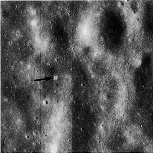
AS16-5444 (P)
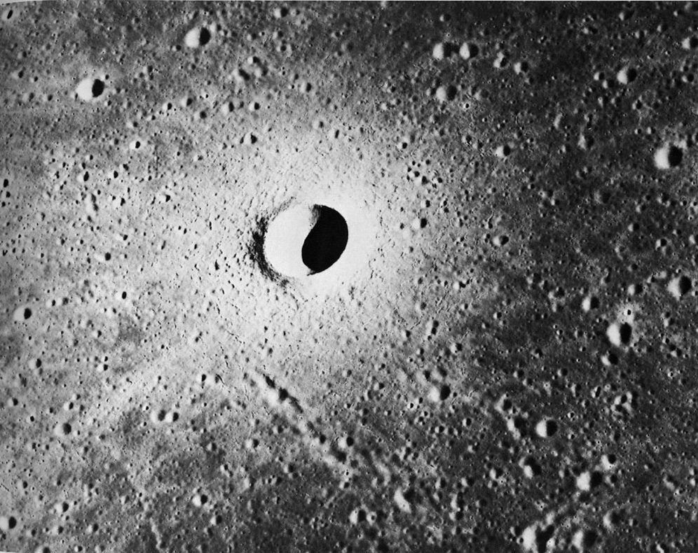
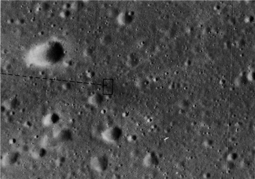
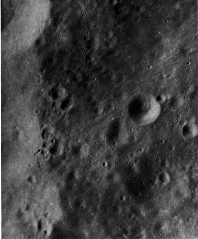
FIGURE 120. - Not quite all the craters on the Moon are natural features. About 28, and possibly as many as 36, according to Ewen A. Whitaker of the Lunar and Planetary Laboratory, University of Arizona, have been caused by man. Only about five of these artificial craters have been visually identified. One of them (centered in the small rectangle) is shown in this enlarged portion of a panoramic camera frame of 24 km 2 in western Mare Cognitum. The more than 2400 craters visible in this small area are typical of the density of craters in many areas of the Moon. First located by Whitaker (1972), the manmade crater is easily identified by its pattern of dark rays interspersed with a few light rays. It was created in February 1971 by the SIVB stage of the Apollo 14 launch vehicle, which was directed to crash onto the lunar surface to generate seismic waves for detection by seismometers set up at the Apollo landing sites. The surface trace of the SIVB's trajectory is shown by a dashed line. - H.J.M.
AS16-5444 (P)
FIGURE 121. - The same crater of figure 120 is shown in more detail in this photograph, an enlargement of the area indicated by the rectangle in figure 120. About 40 m in diameter, the crater differs from most natural impact craters in this size range by having a prominent central peak. - H.J.M.
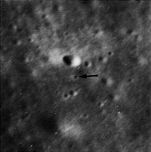
AS16-5430 (P)
FIGURE 122. - An enlargement (approximately 15X) of a panoramic camera photograph showing a crater (arrow) formed in Mare Cognitum by the impact of the Ranger 7 spacecraft. Following an oblique trajectory, Ranger 7 struck the lunar surface on July 31, 1964, while traveling at a velocity of 2.65 km/s. The resulting crater is about 14 m across. Its bright ejecta blanket contrasts with the generally dark blanket around the SIVB crater and is more typical of natural lunar impact craters. - H.J.M.
AS16-4658 (P)
FIGURE 123. - An enlargement of approximately 40X showing another manmade crater. This crater was excavated in the floor of the large near-side crater Alphonsus on March 24, 1965, by the Ranger 9 spacecraft. Prior to its crash, Ranger 9 had transmitted the highest resolution imagery obtained to that date from any spacecraft. Both Ranger vehicles impacted on mare surfaces while traveling at the same velocity along trajectories with the same inclination. It is, therefore, not surprising that the Ranger 7 and 9 craters have, within half a meter, the same diameter. - H.J.M.
AS17-2120 (M)
FIGURE 124. - This photo taken at low Sun angle emphasizes how common secondary impact craters are on the Moon. The primary craters whose ejecta formed most of the secondaries in this part of southeastern Mare Imbrium can be identified by observing the orientation of the secondary crater chains and of the "herringbone" ridges that splay outward from individual secondary craters. The chains are radial to the primary or parent crater and the apexes of the "herringbone" ridges point toward it. The most conspicuous chain and the chain at the left center of the picture are secondary to Eratosthenes, 250 km to the southeast in the direction of the arrows labeled E. Lying athwart these chains is a large younger cluster (arrow C) secondary to Copernicus, 400 km to the southwest. The chains in the extreme upper right corner (arrow T) are secondary to Timocharis whose rim is only 35 km northeast of the pictured area. Most of the other, smaller chains, clusters, and "bird's-foot" gouges can also be traced to Eratosthenes, Copernicus, or Timocharis, but some probably were created by fragments from more distant sources. The largest crater in the scene is Timocharis A, 8 km in diameter. - D.E.W.
AS17-2444 (M)
FIGURE 125. - This oblique view across southern Mare Imbrium looks toward Copernicus, the large crater near the horizon. The distance from the lower edge of the picture to the center of Copernicus is 400 km. The mountains at the edge of Mare Imbrium are the Montes Carpatus, and the large crater near the center of the picture is Pytheas, almost 19 km in diameter. Copernicus is one of the youngest of the Moon's large craters. It is visible from Earth, even without the aid of a telescope because of its bright ejecta blanket and its extensive bright rays. The many chains and clusters of small irregular craters and the many bright streaks or rays extending across Mare Imbrium are caused by the secondary impact of debris ejected from Copernicus. The viewing angle accentuates the radial pattern of the secondary impact features. The Sun angle is sufficiently low to show their relief, but high enough to show the contrast between the bright streaks and the normal dark mare surface. As in figure 124, herringbone ridges point toward the primary crater, and the flaring sides of the secondary craters point away from it. The arrow midway between Copernicus and the left edge of the photograph points to a less common pattern of secondary craters; these are concentric to Copernicus. - M.C.M.
AS17-2291 (M)
FIGURE 126. - Here is another area in southern Mare Imbrium that shows a profusion of bright rays and chains of secondary craters from Copernicus, which is located about 380 km southeast of the center of the picture. The large crater near the left (west) side is Euler. (See figs. 64 and 137 to 139.) Here lighting conditions are ideal for showing how the material ejected from Copernicus secondaries is splashed downrange (away from Copernicus) to form the herringbone ridges and the bright patches or streaks. Individual craters and their associated ridges sometimes combine to form a pattern that resembles the imprint of a bird's foot. The area within the small rectangle is shown in much more detail in figure 127. - H.M.
AS17-3093 (P)
FIGURE 127. - A secondary Copernicus crater chain is enlarged in this view. (See fig. 126.) Its elongate shape, the irregular form of the individual craters, and the splashed appearance of their ejecta are clearly discernible. Also present in this view are two or three groups of craters (arrows) that are also of secondary impact origin, but are different from the Copernicus chain. They occur in clusters, not chains. The craters within the clusters are smaller and more regular in shape and do not have the splashed appearance of the Copernicus secondaries. At arrow 2, some of them are superposed on-and hence are younger than-the Copernicus chain. A few have faint herringbone ridges that veer toward the west, indicating that the primary crater lies in that direction. Except for the familiar crater Aristarchus (fig. 165), which is 580 km west of this area, there are no other large craters that are also young enough to have been the cause of these secondaries. Aristarchus is, furthermore, younger than Copernicus. For these reasons Aristarchus crater is the most likely source of the material that landed here to form the clusters of craters. - G.W.C.
AS16-4653 (P)
FIGURE 128. - These three clusters of secondary craters (see arrows) are on the east flank of the larger crater Ptolemaeus near the center of the Moon's near side. Each cluster has a ridged and hummocky appearance. The primary crater has not been identified in this case, but the configuration of the clusters tells us that it must be to the south of Ptolemaeus. Note that the south-facing side of each cluster is more sharply defined than the northfacing side. This is a consequence of the oblique trajectory of impacting fragments that causes the ejecta of the secondary craters to be propelled away (down range) from the primary crater. Observations of manmade impact craters have shown that the individual fragments within a cluster of secondary debris strike the surface nearly simultaneously. In the process, ejecta from one secondary collides and interferes with ejecta from adjacent craters, producing a ridged and hummocky surface. - H.J.M.
AS16-4653 (P)
FIGURE 129. - The secondary crater cluster near the lower edge of figure 128 is enlarged to show more detail. The largest crater within the cluster is about 600 m wide. The small, sharp, circular craters are primary craters that postdate the cluster. Some poorly defined V-shaped ridges at the south edge of the cluster point southward toward the primary crater. The effects of the secondary cratering are much more extensive than was apparent in the smaller scale picture. The finely lineated terrain west and north of the cluster is caused by a great many parallel and subparallel ridges, gouges, grooves, and barely visible small irregular craters. They are apparently caused by the impact and deposition of material ejected from the secondary craters. Craters formed during this stage are tertiary craters but are rarely distinct enough to be recognized. Several possible examples are indicated by arrows. - H.J.M.
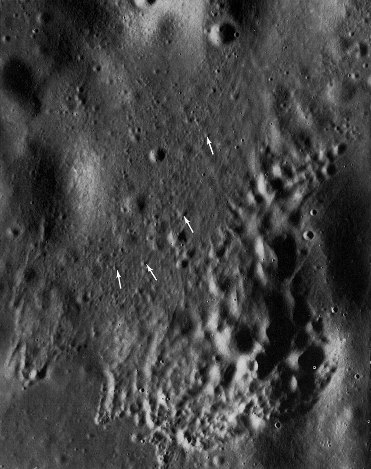
AS16-1973 (M)
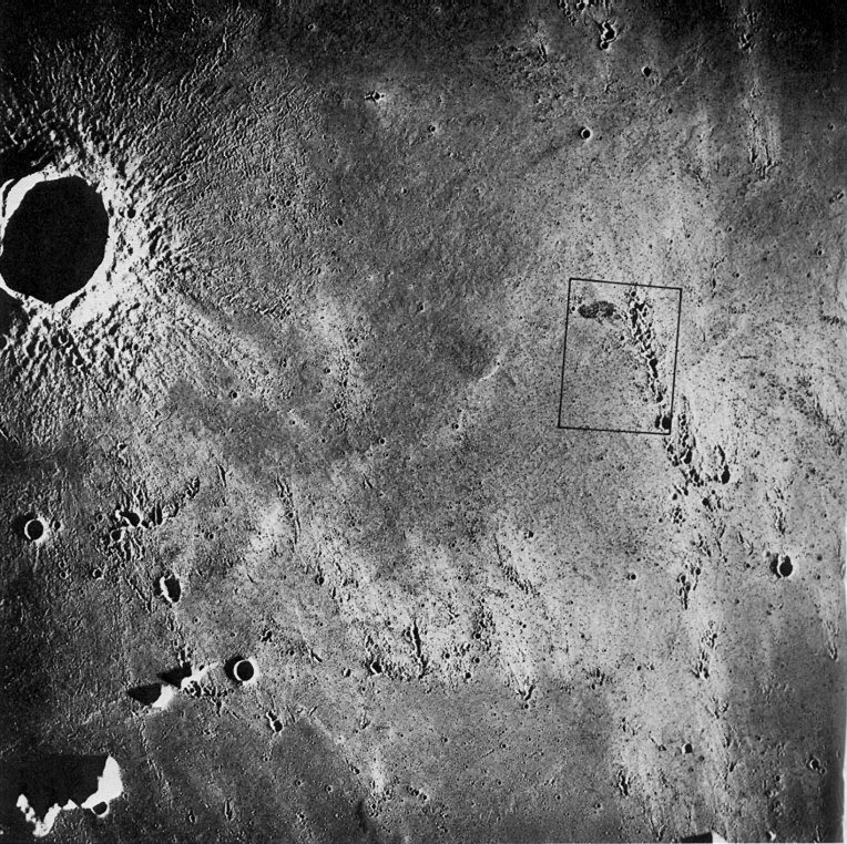
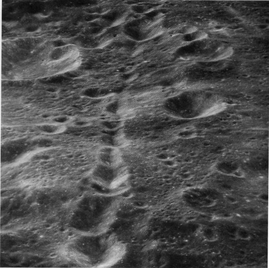
FIGURE 130. - The Davy crater chain (arrow) is one of the most spectacular chains of craters on the Moon. It extends for about 50 km across the floor of the large, very old crater Davy Y (Y) and onto its eastern rim. The chain may be related in origin to the pair of irregular craters Davy G (G) and Davy GA (GA), 75 km from the furthest end of the chain. Two origins have been proposed. Some lunar geologists believe it is a chain of secondary impact craters, and others believe it is a line of volcanic craters. The simple geometry of the Davy chain, the symmetry and uniform spacing of its individual craters, and its alinement with Davy G strongly support, in this writer's opinion, a volcanic origin. Also arguing against a secondary impact origin is the fact that the Davy chain is a lone feature. There are no other similar chains with this trend in the area. As was shown earlier in this chapter (figs. 124 and 125), secondary crater chains tend to occur in large numbers within the belt of secondary craters surrounding a large primary crater.
On Earth some rocks from deep within the crust have been brought to the surface through volcanic orifices, thus providing a means of studying material that would otherwise be inaccessible. For this reason the Davy area was once seriously considered as a landing site. However, when the originally planned number of Apollo missions was reduced, the Davy area was one of those eliminated. - H.M.
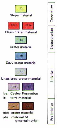
FIGURE 131. - This is a reduced version of part of a geologic map of the Davy area compiled by R. Hereford of the U.S. Geological Survey. Photogeologic mapping did not provide an unambiguous answer to the question of the origin of the Davy chain, but did provide much information on the succession of events that shaped this part of the Moon's surface. Following the map explanation, the succession is briefly as follows: (1) An early period of intense cratering during which the large crater Davy Y was excavated and its rim uplifted. (2) A presumably brief period during which the Cayley Formation and one other plains unit were deposited. (The origin of the Cayley as a semifluid cloud of ejecta from the Imbrium basin was discussed in figs. 46, 54, and 55.) (3) A long period when scattered medium-sized craters and their deposits were formed. (4) The formation of the Davy crater chain and the larger, presumably volcanic, craters Davy G and Davy GA. (5) Finally, mass movement of material on steep slopes to form relatively fresh slope deposits and sporadic impact by very small bodies that made craters too small to be shown at the scale of the map. - G.W.C.
|
|
|
Dashed where inferred, queried where doubtful
|
|
|
|
|
|
Trough Line marks axis
|
|
|
|
|
|
Crater rim crest
|
|
|
|
|
|
Chain crater rim crest |
|
|
|
|
|
Depression |


AS16-1671 (M)
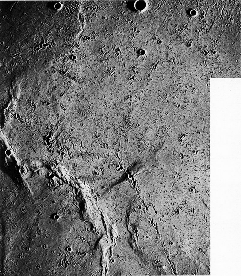
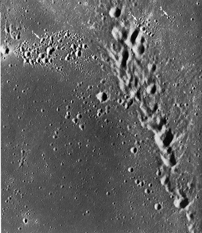
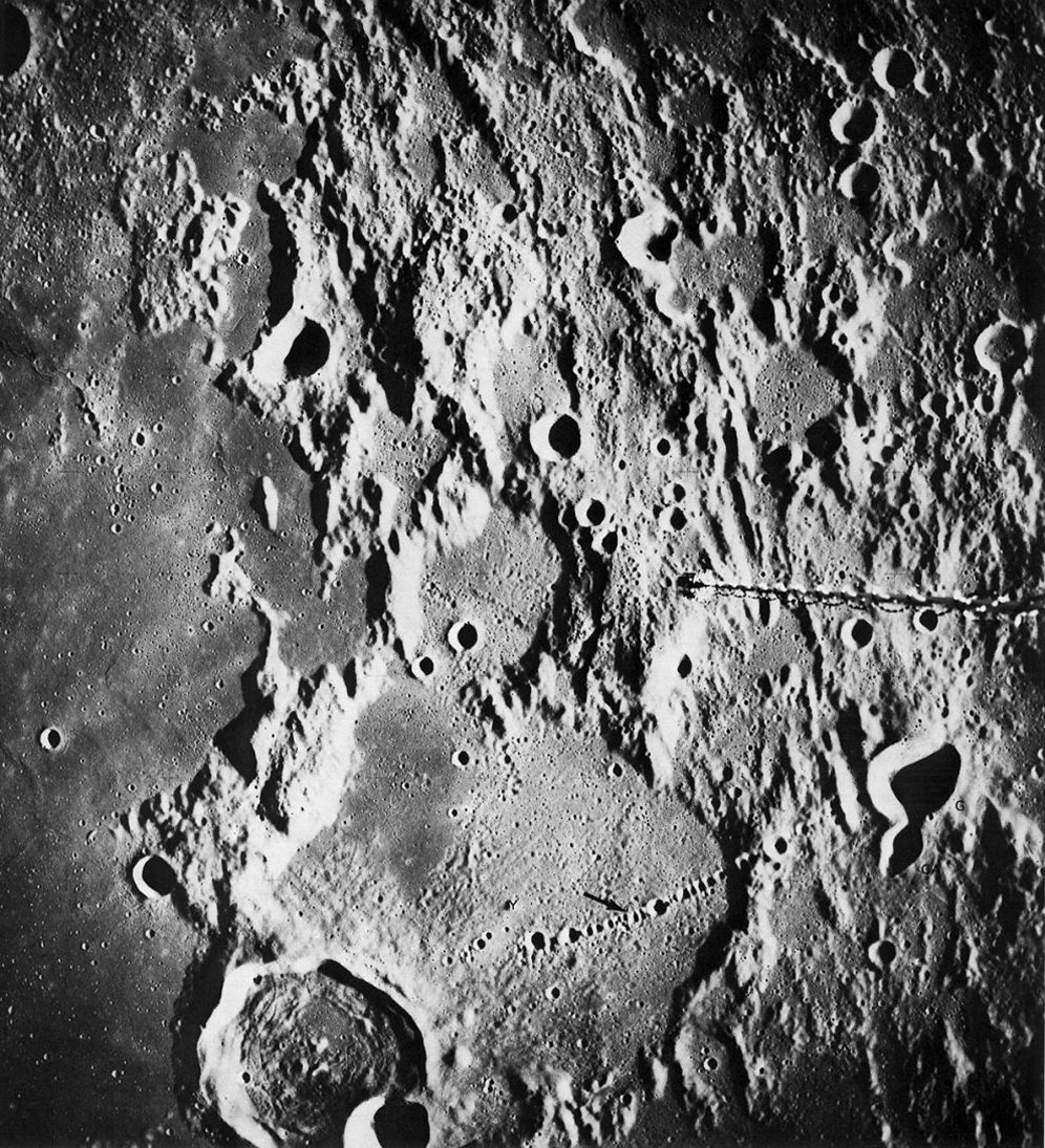
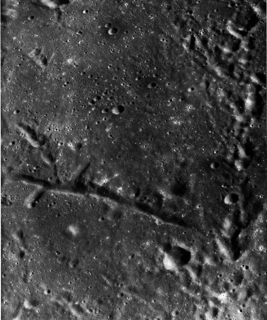
FIGURE 132. - The crater chain extending from the large arrow at A is part of a discontinuous lineament that grazes the northeast rim of Ptolemaeus (left), and that may extend as far as 720 km beyond the edge of the picture. The origin of the chain is perplexing. In some respects it resembles Imbrium sculpture (figs. 36, 47, 48, and 53), except that the individual craters in the chain are more circular and more distinct. An apparent difference in freshness of craters within the chain (as at B and C) suggests that the chain may have formed by volcanism localized along a tectonic fracture. On the other hand, the lack of visible faulting in this area and the strong resemblance of this chain to some secondary crater chains suggest the more likely alternative that it originated by secondary impact, perhaps by ejecta from Schrodinger, a relatively small double-ringed basin in the south polar region. - C.A.H.
AS16-1276 (M)
FIGURE 133. - This photograph shows the crater chain of figure 132 in its regional context (large arrows). Trending east-southeast, the chain sharply transects the Imbrium sculpture, which trends south-southeast (smaller arrows near margins). The difference in trends argues strongly against a common origin and somewhat less strongly against a related origin. The laser altimeter on board the Apollo 16 CSM showed that the area directly east of Ptolemaeus was one of the highest areas on the near side of the Moon along the ground track. The other anomalously high area was in the vicinity of the Apollo 16 landing site near Descartes. Also in the Ptolemaeus area the Apollo 16 mass spectrometer recorded an excepionally high ratio of aluminum to silicon. The relationship between high elevation and high aluminum content and the presence of a prominent crater chain are probably more than coincidental. One interpretation is that volcanism in this part of the highlands extended into a later period of time than in most other highland areas on the near side and that more differentiated materials were extruded. The crater chain may be related in origin to this late-stage eruption. - H.M.
AS17-149-22838 (H)
FIGURE 134. - This oblique view taken with the Hasselblad camera shows a crater chain on the far side, about 500 km north of Tsiolkovsky. For an idea of the scale, the large crater near the upper left corner is about 26 km wide. The origin of this chain is controversial. To some geologists, the irregular shape of many of the craters suggests that the chain was formed by the impact of a stream of ejecta from a large primary crater. The presence of herringbone ridges would have strengthened this interpretation, but none are visible; perhaps the high Sun angle and the oblique viewing angle of this scene have obscured them. To others the simple geometry of the chain suggests a volcanic origin. However, there is an apparent lack of faulting to control the alinement of the craters and an apparent absence of a blanket of volcanic ejecta. The origin of this chain may not be decipherable until, and unless, additional photography becomes available. - G.W.C.

AS17-2321 (P)
FIGURE 135. - This crater chain in southern Mare Serenitatis is clearly of internal origin because it is lined up parallel to several fault valleys or grabens. The craters in the chain do not appear to have any rims; consequently, they may have formed by collapse and not by the explosive ejection of volcanic material. The large crater in the right side of this scene, however, has a rim and so cannot be the result of collapse alone. The finely lineated texture across the left side of the photograph is caused by ejecta from the crater Dawes to the south. - H.A.H.
AS16-4530 (P)
FIGURE 136. - Linear features of external and internal origin are contrasted in this area of southernmost Mare Tranquillitatis. The northtrending line of overlapping, very irregular craters along the east edge of the picture is clearly a chain of secondary impact craters. Its trend is radial to Theophilus, a large crater of early Copernican age that lies about 105 km south of this area. The flaring shapes of some of the craters and their state of preservation also suggest that Theophilus is the primary crater. The narrow, straight rifle or graben that extends westward across the picture is clearly of internal origin. It formed when tensional forces ruptured the crust, causing the floor of the rifle to subside along faults. As is discussed in chapter 6, straight rifles are commonly the sites of volcanic cones or of blankets of volcanic ejecta; however, there are no signs of volcanism here that can be related to this rifle. - M.J.G.
AS17-3107 (P) | AS17-3105 (P) | AS17-3103 (P)
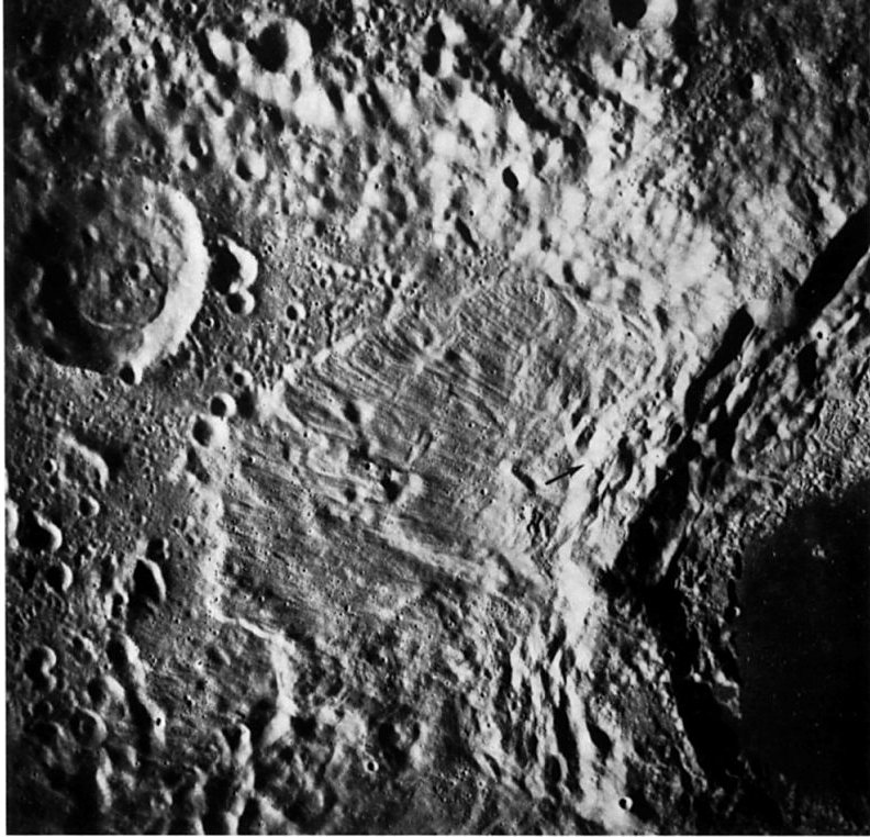
FIGURE 137. - Parts of three frames from the Apollo 17 panoramic camera were mosaicked to form this high- resolution view. The crater Euler in southwestern Mare Imbrium is an exceptionally fine example of a young mediumsized crater. Twenty-seven km in diameter, Euler has most of the features that typify young craters in this size range. Its sharp rim shows little evidence of rounding. A solid blanket of ejecta is visible for approximately one- half crater diameter outside the rim, and the radial pattern of secondary craters, crater clusters, ridges, and grooves is visible outward to a full crater diameter. Terraces formed by slumping of the steep crater walls, probably contemporaneously with the formation of the crater, are clearly evident. The steepness of the walls and the fact that the crater floor is below the level of the surrounding mare surface indicate that relatively little erosion and infilling have occurred. Other features typical of medium-sized craters are the central peak and the level floor surrounding the central peak. The pattern of ejecta around Euler is notably asymmetric because the area was later flooded by mare lavas that inundated parts of the ejecta blanket and other ejecta features. - M.C.M.
AS17-2922 (M)
FIGURE 138. - This similar view of Euler, taken with the Apollo 17 mapping camera, is included because it shows even more clearly the relationship between the ejecta from Euler and the surrounding mare lavas. The youngest lava flows in the Imbrium basin (Schaber, 1973) have overlapped and embayed the Euler ejecta from the north, west, and south-especially at places marked by arrows. The long sinuous rifle south of Euler is associated with the late stage lava flooding. The clusters of large secondary craters (S) are from Copernicus, 400 km to the southwest. In the southeast part of the picture some of these secondary craters and their associated ray deposits overlie the mare lavas. The following sequence of events therefore took place: (1) the Euler impact, (2) flooding by lava, and (3) the impact of material ejected from Copernicus. - G.G.S.
AS15-0274 (P)
FIGURE 139. - In this oblique view of Euler some details are shown that are not visible in figures 137 and 138. Note, for example, the ledges (L) of bedrock cropping out along the south wall and the low terraces (T) at the points of contact between the slump masses and the floor. They may be aprons of debris or "bathtub rings" of lava like those shown earlier in figure 69. This oblique viewing angle also enhances the polygonal outline of Euler's rim crest and the size and ruggedness of the huge masses that have slumped from the walls. - G.G.S.
AS14-70-9671 (H)
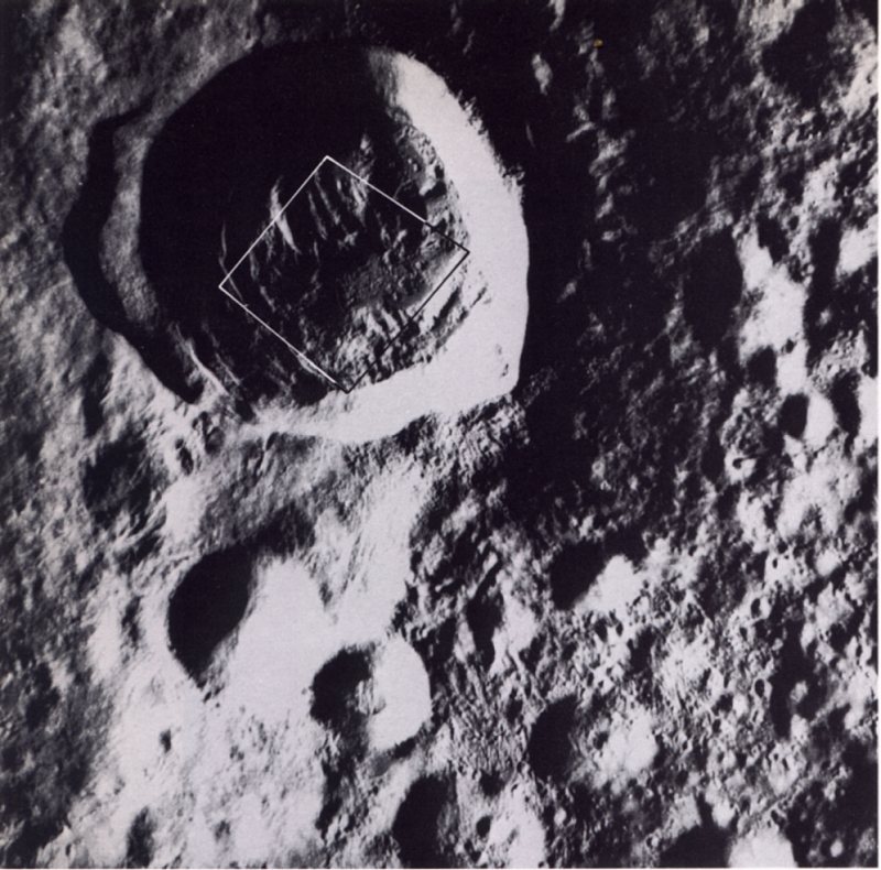
FIGURE 140. - This crater on the lunar far side is similar in age and size to the near- side crater Euler (figs. 137 to 139). It is located midway between the craters Becvar and Langemak. Thirty-six km in diameter, it was informally called the "Bright One" by the Apollo 14 astronauts because of its bright ejecta and ray pattern. The bright halo that surrounds the crater is about 150 km in diameter. Its brightness is not evident in this view because the picture was taken when the Sun angle was low. The radial pattern of dunelike ejecta around the crater is most apparent where the Sun's rays are perpendicular to the direction of ejecta flow, as in the lower part of the picture. The hummocky or bumpy floor of the crater is caused largely by material that has slumped from the walls. Stuart A. Roosa, the Apollo 14 CMP, used a handheld camera with an 80-mm lens for this photograph. Later, using a 500-mm lens, he photographed in much more detail that part of the floor of the crater outlined in this photograph and shown in figure 141. - M.C.M.
AS14-72-9975 (H)
FIGURE 141. - When photographed with the 500-mm lens, the abundance of blocks (bright spots with shadows extending to the right) attests to the freshness of the materials on the floor of the "Bright One." Material that has flowed and in some instances formed smooth-surfaced "pools" is evident in much of the area. Arrows mark the edge of a major flow distinguished by its surface texture, color (in the original negative), location in a topographic low, and clearly defined border. Note that the abundance of boulders in the flow is much less than in nearby areas, presumably because the flow has buried most of the boulders in its path. Scientists generally agree that material has flowed here, and on the floors and flanks of many other craters, but the nature of the material that has flowed is a matter of debate. - M.C.M.
AS17-3062 (P)
FIGURE 142. - This oblique view of the crater Timocharis in southeastern Mare Imbrium illustrates how the original diameter of a crater is enlarged by slumping of its walls. Its present diameter is about 35 km. The sparsity of small superposed craters on the walls of Timocharis-in contrast to their density on its floor and rim-is caused by the erosive effect of downslope movement of material on the steep walls. Timocharis, like many other young impact craters of similar size, possesses a well-defined central peak complex. Such structures are believed to result from elastic rebound of the bedrock immediately after the impacting event. However, the central peak of Timocharis apparently has been substantially modified by a large superimposed crater. - G.G.S.
AS15-9866 (P)
FIGURE 143. - High Sun views such as this often show fascinating dark and bright patterns that would be overwhelmed by highlights or shadows if the Sun were lower in the sky. This view of the 17-km-wide crater Jansen B shows numerous bright avalanche deposits on the steep crater walls, apparently originating at outcrop ledges near the top of the wall. Most avalanches stop in a moat at the base of the wall, but a few in the foreground extend out onto the irregular, inward- sloping floor. The floor is a jumble of slump blocks. Avalanching appears to be a major means of erosion on steep lunar slopes. - K.A.H.
AS15-9874 (P)
FIGURE 144. - This is a near vertical view of the crater Dawes, 18 km in diameter. Morphologically it is typical of many lunar craters in the 15- to 20-km size range. It lacks terraced walls and distinct central peaks but has an extremely rough floor. Small terracelike structures on the crater floor (upper left, lower right) occur where the wall is bowed outward and probably represent slump deposits where portions of the crater wall have collapsed into the crater. Local stratigraphy is revealed in the walls of the crater, and material of different albedo is seen streaming down into the crater from various levels. The dark layer clearly visible in the upper part of the crater wall represents the thin mare deposits in this part of northern Mare Tranquillitatis. The lighter gray material below it is a combination of underlying submare material and talus from units higher on the crater wall. The highest unit (white and gray) probably represents the ejecta blanket and may consist primarily of lighter lunar crustal material excavated from beneath the mare. - J.W.H.
AS15-9328 (P)
FIGURE 145. - Outcrops of layered rock are strikingly evident in the upper part of the far wall of the crater Bessel (17- km diameter) in south-central Mare Serenitatis. The outcrop is most evident where it forms shadows; however, the dark debris that streams downslope from the layered rock is visible even on parts of the crater wall where the Sun has washed out all details of relief. The outcrop is at a uniform distance below the crater rim, indicating that the strata are horizontal. Thus, Bessel furnishes convincing evidence that mare surfaces are underlain by dark layered rock. The dark rock is now known to be basalt that accumulated as successive flows or layers of lava. Bessel is youthful enough that boulders are abundant on its rim and floor. An anomalously high number of boulders is visible in and around the 750-m diameter crater (arrow) on the floor. - M.C.M.
AS17-3081 (P)
FIGURE 146. - The Apollo 17 panoramic camera provided this high-resolution, enlarged view of the south wall of Pytheas. Pytheas is about the same size as Bessel (fig. 145), but is located in south-central Mare Imbrium almost 1100 km west of the latter. The outcrops in the walls of the two craters are remarkably similar. These and the many other craters in mare areas that contain outcrops of dark horizontally layered rock demonstrate the moonwide uniformity of conditions in the upper part of the mare basins. - M.C.M.
AS17-2265 (P)
FIGURE 147. - This oblique view looks south over the 26-km-diameter crater Proclus in the highlands at the western edge of Mare Crisium. Proclus is a young rayed crater that is distinctive because of the marked asymmetry of its ray system-a characteristic visible even in Earth-based telescopic views. The excluded zone is along the southwest edge (top of photograph) but is visible in this moderate Sun photo only as a slight albedo change. Laboratory experiments suggest that a low trajectory angle might account for the asymmetry. A number of large blocks can be seen at the edge of the crater rim. The exceptionally large block (arrow) is about 200 m wide and, judging from the length of the shadow it casts, nearly as high. As in several other craters shown in this chapter, a darker layer is present in the upper part of the crater wall. - J.W.H.
AS17-2007 (M) | AS17-2006 (M)
FIGURE 148. - This pair of overlapping medium-sized craters illustrates some of the criteria used to determine relative ages. Material ejected from the larger polygonal crater on the left partially fills the smaller crater on the right; thus, the crater on the left is younger. Furthermore, the wall of the large crater is complete, whereas the west wall of the smaller crater is absent, obviously having been destroyed by the larger crater. Even if the two craters did not overlap, the sharp rim, terraced walls, and prominent central peak of the larger crater clearly identify it as the younger of the two. The frames used in the stereogram were selected to show exaggerated relief, a technique very helpful to photointerpreters in determining shapes and relative elevations of surface features. The two craters are located in the rugged terrain of the far-side highlands approximately 250 km north of the prominent crater Tsiolkovsky. The photograph below is an oblique view of the same pair of craters. It is included, not because it is a more dramatic view, but because it shows from another perspective that one crater clearly is superposed on the other. - M.C.M.
AS17-2773 (P)
The photograph below is an oblique view of the same pair of craters. It is included, not because it is a more dramatic view, but because it shows from another perspective that one crater clearly is superposed on the other. -M.C.M.
AS16-122-19580 (H)
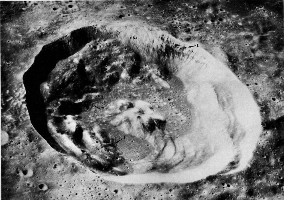
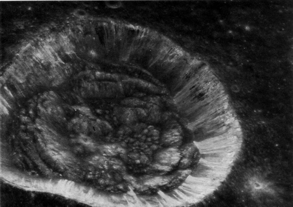
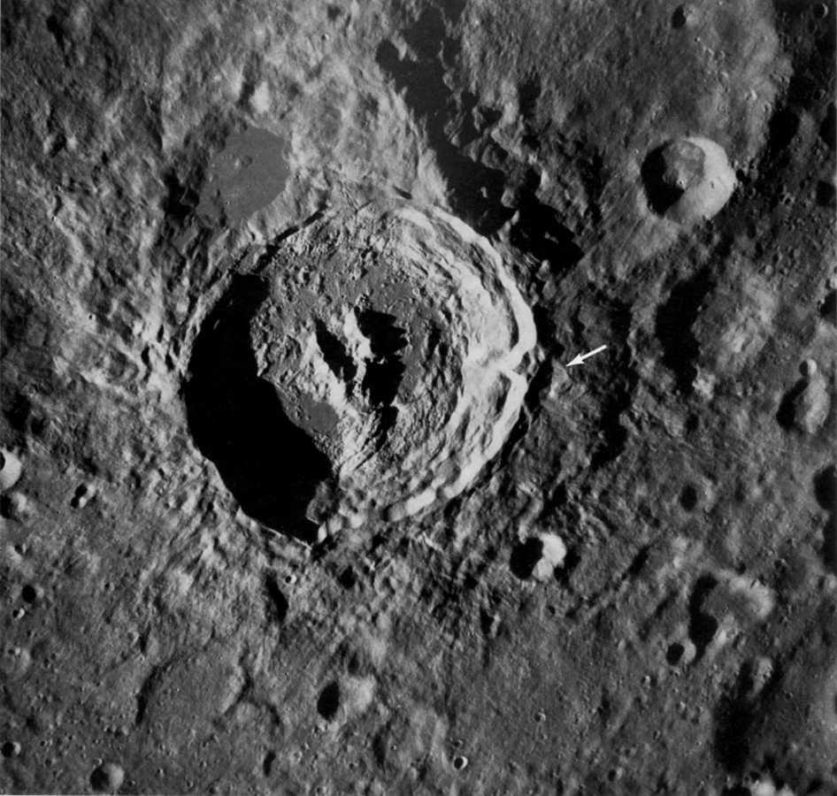
FIGURE 149. - This vertical view of the crater King on the lunar far side was taken with the Apollo 16 Hasselblad camera. King, approximately 75 km in diameter and 4 km deep, is one of the most interesting features on the far side. It is a superb example of a youthful, large crater. It attracted much attention and was the object of numerous scientific studies (e.g., El-Baz, 1972b; Young, Brennan, and Wolfe, 1972). King is the freshest crater on the far side in its size range. Among its many interesting features are (1) a unique lobster-claw-like central peak, (2) a flat poollike area of dark material on the north rim believed to have once been molten, (3) a very-well-developed field of fine ejecta extending outward for approximately two crater diameters, and (4) a massive landslide on the southeast rim (see arrow). In this view the southern part of the central peak has a distinctly ropey appearance and is segmented parallel to the terraces of the adjacent crater wall. The low Sun illumination enhances the fine texture of King's ejecta. Northeast of King the ejecta mantles an old large crater and in the southwest corner of the picture it mantles a relatively smooth terra unit. The slightly raised plateau on which the crater is situated may be part of the ring of an old basin. - F.E.- B.
AS16-120-19268 (H)
FIGURE 150. - The similarity in appearance of the southern part of the central peak and the slump terraces on the southern wall of the crater is emphasized in this oblique view of the crater King. The parallelism of the two arms of the central peak and the southern segment of the peak suggests that the unique shape of the structure is caused by a preexisting tabular body that was excavated during the formation of the crater (El-Baz, 1972b). Numerous comical structures with summit pits are present on the crater floor in the lower right part of the photograph. - F.E.- B.
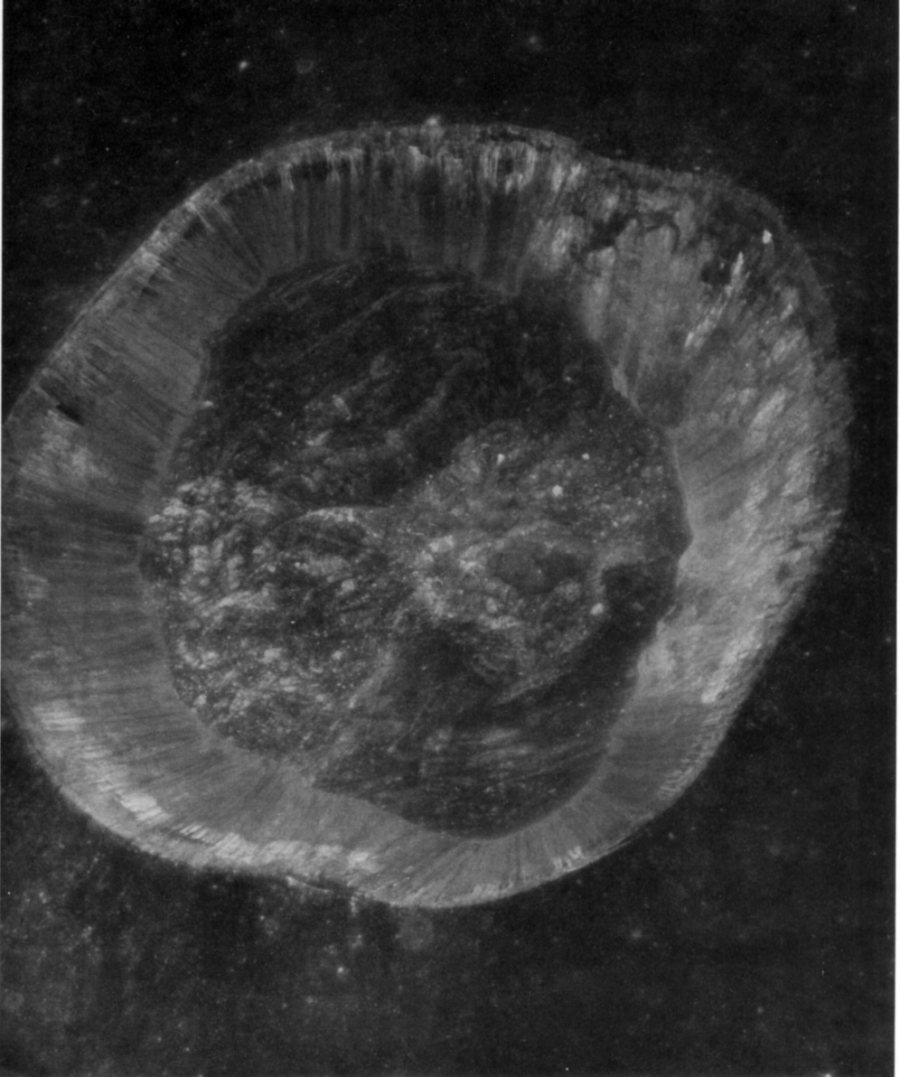
AS16-4998 (P)
FIGURE 151. - The northern part of the central peak complex of the crater King is shown in this enlarged view. The massifs forming the arms of the central peak trend approximately north-south. They are crossed by linear valleys that are the surface expressions of faults. The blocks that litter the peaks attest to the freshness of the structure and, therefore, of the crater King itself. The floor material surrounding the massifs is very hummocky and shows many flow patterns. Arcuate flow boundaries, flow channels, and cooling cracks indicate that this material was once molten, perhaps because of shock melting at the time of the crater formation. - F.E.- B.
AS16-5000 (P)
FIGURE 152. - A close look at the western part of the floor of the crater King reveals many similarities to the floors of other fresh craters such as Copernicus or Tycho. The crater wall rises steeply along the left. Cracked and corrugated lavalike material occupies low areas between hills and knobs on the floor. Some cracks extend across hills, suggesting that those hills are completely covered by the lavalike material. Rocky outcrops on other hills (some examples are identified by arrows) show that they are made of hard rock. - K.A.H.
AS16-4996 (P)
FIGURE 153. - This greatly enlarged part of a panoramic camera photograph shows a small area in the eastern part of the floor of the crater King. The large mass in the left part is one example of the many domed structures that occur in the floor of King. It is trisected by depressions in the shape of an inverted "Y" representing three faults; one trends north-south (1), another northeast-southwest (2), and the third northwest-southeast (3). In the area of the fractures and the resulting grabens and depressions, there are numerous blocks indicating that tectonic movement has occurred relatively recently. The northwest-southeast trending fault continues across the level floor to the lower-right corner of the picture. An intricate pattern of finer fractures trending in many directions is also present in the level part of the floor. The partly arcuate nature of the fractures suggests that some may represent cooling cracks. - F.E.- B.
AS10-304349 (H)
FIGURE 154. - This oblique view looking north across the northern part of the crater King was taken by the Apollo 10 crew. The very dark patch on the northern wall of King near the center of the photograph was first observed on that mission and has since been the subject of detailed visual study and orbital photography. The rocks of this dark patch are the darkest material yet recognized in the far-side highlands and are surrounded by brighter material. Two bands of this brighter material extend northward for approximately 30 km beyond the crater. In the near field, at the lower left, is the northern half of the Y-shaped central peak of King. A dark pool of relatively smooth material is visible just beyond the alternating bands of dark and light rocks on the north rim of the crater. The alinement of the arms of the central peak, the bands of dark and white rocks, and the concentrations of blocky material on the central peak complex and on the crater floor all suggest that when this crater was formed, a preexisting linear body was encountered and partly exhumed. - F.E.- B.
AS16-120-19266 (H)
FIGURE 155. - The Apollo 16 astronauts captured this spectacular view of the large dark "pool" on the north flank of the crater King (left) as they approached from the east. The pool (also known as a lake, pond, or playa) is in an old crater swamped by King ejecta. The maximum width of the pool is about 21 km. The peculiar dark material that forms the large pool and also coats adjacent hills was first discovered on Apollo 10, and was later seen again from Apollo 14. The most exciting part of the discovery had to wait until the mapping and panoramic cameras of Apollo 16 showed that this material contains some of the freshest and most spectacular flow structures on the Moon. These structures, some of which are seen in the following figures, show that the material behaved like lava. The material is very similar in appearance to that filling parts of the floor of King. -K.A.H.
AS16-5000 (P)
FIGURE 156. - Here the Apollo 16 panoramic camera views the same large pool of dark material. For orientation, the hill identified by an arrow is the "island" near the center of the pool in Figure 155. In the highlands surrounding the main pool are many small pools. Their surfaces merge with a veneer of similar material on adjacent slopes, as if most of the rim of the old crater had once been coated by a fluid rock that partly drained off to accumulate in depressions. Cracks (C), flow channels (FC) near the middle of the picture, and numerous wrinkles show that the material flowed like lava toward the main large pool. Whether the lavalike material is volcanic lava or rock melted by the impact is in vigorous debate. The material is restricted to the north rim of King where ejecta is also most concentrated. If the ejecta is concentrated on the north because north was downrange from an obliquely impacting body, that condition would support an impact origin for the dark material. - K.A.H.
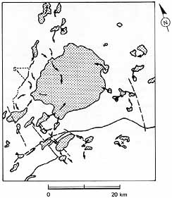
FIGURE 157. - A schematic map based on figure 155 shows some of the geologic relationships. The solid line marks the rim crest of the crater King and the stipple pattern delineates the many pools of smooth dark material. Dashed lines represent lineaments that probably are the surface expressions of faults. Arrows indicate the directions of flow of the molten or partially molten material from higher to lower levels; most finally accumulating in the large pool in the center. A scarp whose origin is not fully understood, but which may possibly be the result of splashing of the molten material from the impact site onto a slope is indicated by S. - F.E.- B.
AS16-5000 (P)
FIGURE 158. - This enlargement of figure 156 shows details in the lavalike materials. The flow features are so young that younger cratering events have not obliterated them. The prominent leveed flow channel in the center of the picture indicates that the material flowed downhill in the direction of the arrows toward the large pool. Like terrestrial volcanic lava, the material is locally compressed into festoonlike corrugations that arch "downstream." In other areas, especially where draped over hills, the material has been stretched and dense patterns of cracks have formed. A linear texture trends northwestward across much of the area shown, but is mostly clearly visible in the lower right corner. It is the expression of King's ejecta blanket underneath the veneer of the lavalike material. If the lavalike material is impact melt, it must have coated the ejecta and drained downhill after the ejecta flowed radially away from King. - K.A.H.
AS16-1578 (M)
FIGURE 159. - The ejecta blanket of King fills this entire scene except for the crater itself and a few small superposed craters. The ejecta coats larger craters, such as the two on the right edge, and completely swamps smaller ones. A large lobe in the ejecta at lower center has been compared (El-Baz, 1972b) to an apparent landslide at Tsiolkovsky (figs. 175 and 176). Close inspection of the surface of the ejecta blanket reveals fine lineations that are concentric near the rim crest and radial further out. Where slopes are encountered, the radial lineations veer from their normal direction to swerve down the slopes. - K.A.H.
AS16-1579 (M)
FIGURE 160. - An enlarged view of the area outlined in figure 159 shows the concentric dunelike lineations more clearly. A few of the lineations veer from concentric to radial in orientation. The outward change on a broader scale from concentric to radial patterns also occurs at other fresh craters, and probably records changing conditions of flow as the ejecta was transported outward at high velocity. On the crater wall, numerous fine fractures parallel the terraced slump blocks, much as in landslides on Earth. - K.A.H.
AS16-120-19231 (H)
FIGURE 161. - The lobate scarps in the foreground are a lunar feature seen as Apollo 16 flew over the margins of King's ejecta blanket. This view looks away from King and is centered about 50 km from its rim crest. The lobes appear to border thick flows or slide masses of King ejecta. Beyond the lobes in the upper left part of the picture the ejecta is thin or absent. - K.A.H.
ASI6-5006 (P)
FIGURE 162. - Here is an enlarged vertical view of more flow lobes immediately south of those in figure 161. Fine lineations radial to King are prominent in the ejecta blanket behind (southeast of) the lobate fronts. The term "deceleration lobe" has been applied because the lobes occur only where the ejecta slowed down and came to rest on slopes that face toward King. They resemble terrestrial rock avalanche deposits that came to rest after climbing a small slope. Some lobes overlap each other outward like shingles. The sketch shows what would probably be seen in a cutaway view. The arrow shows the direction of movement of the ejecta over the old landscape. - K.A.H.
AS16-4815 (P)
FIGURE 163. - Here the panoramic camera sees the edge of King's ejecta blanket 75 km northeast of the crater. The bright slope along the left side of the photo faces both the Sun and King. It apparently acted as a barrier for the ejecta surging outward from King, for there are small deceleration lobes on the slopes. Most of the plateau east of the slope is pocked by small craters that were not covered by the ejecta blanket. However, a belt of linear dunelike features radial to King crosses part of the plateau from lower left to upper right. Careful inspection shows that the lineations are downrange from a cluster of small irregular craters (arrow) at the left edge of the plateau. These are part of a field of secondary impact craters that completely surround King's ejecta blanket. Debris thrown out on low-trajectory paths from King made the secondary craters and apparently splashed debris downrange. Closer to King, the continuous ejecta blanket is lineated in the same way as is the secondary ejecta. Perhaps much of the continuous ejecta blanket is also formed of material splashed out by secondary impacts. - K.A.H.
AS17-151-23260 (H)
FIGURE 164. - The large crater Copernicus has served as a type example of lunar impact craters since the classic analysis was made by E. M. Shoemaker (1962). Bright rays of ejecta radiate outward from Copernicus across a large part of the Moon's near side. Material from one of the rays may have been sampled at the Apollo 12 landing site, 370 km south of the center of the crater. This photograph shows how the crater appeared from the Apollo 17 spacecraft looking southward over the Montes Carpatus (Carpathian Mountains). Notice that the rim deposits immediately adjacent to the crater have a very crisp, blocky appearance in contrast to the softer appearance of the rest of the ejecta blanket. This crisp zone is also found on many other craters and suggests the ejecta here was swept clean by some erosion process late in the cratering event. The terraced slumps on the crater wall appear like giant stair steps leading to the floor, 3 to 4 km below the rim. The 1-km-high central peaks were made famous in 1966 by a "picture of the century" view looking into the crater from the south by Lunar Orbiter 2. Now Apollo has given us scores of even more spectacular photographs. - K.A.H.
AS15-0326 (P)
FIGURE 165. - Aristarchus is a large crater on the edge of a plateau within northern Oceanus Procellarum. In this scene the crater is viewed obliquely from the north. One of the brightest and youngest craters of its size on the near side of the Moon, Aristarchus is believed to be younger even than Copernicus. The general appearance of Aristarchus and of parts of the plateau around it led Alfred Worden, the Apollo 15 CMP, to describe this part of the Moon as "... probably the most volcanic area that I've seen anywhere on the surface." For many years before the Apollo missions, Earth-based viewers had reported telescopic sightings of transient events centered on Aristarchus. These brief, subtle changes in color or in sharpness of appearance have been suggested as evidence for volcanic activity or the venting of gases from the lunar interior. The sightings are controversial, but Aristarchus remains a center of interest. -M.C.M.
About 39 km in diameter, Aristarchus is on the borderline between medium-sized and large- sized craters. We have included it among the large craters because its welldeveloped concentric terraces are characteristic of most large craters that have not been too severely degraded. Its terraced walls, as well as its arcuate range of central peaks, are particularly well shown in this view. The walls and parts of the crater floor are extremely rough and cracked, a characteristic feature of other young impact craters of this size range, such as Tycho and Copernicus. The rough deposits in the floor are probably made up largely of shockmelted material formed at the time of the impact. The inner, rougher portions of the rim show a series of channels, lobate flows, and smooth puddlelike deposits that may represent shock-melted material deposited on the crater rim. The outer, smoother portions show the rhomboidal pattern characteristic of crater ejecta blankets. - J.W.H.
AS16-0692 (M)
FIGURE 166. - Theophilus is a relatively young crater similar in size but slightly older than Copernicus (fig.164). It lies on the eastern edge of the Kant plateau, an elevated area in the Central Highlands along the northwestern margin of Mare Nectaris. Part of Nectaris is visible as the smooth. dark area near the horizon at the left edge. Like Copernicus and Aristarchus, Theophilus has ruggedly terraced walls and a complex central peak protruding through a level floor. Smooth-surfaced material is present in "pools" at various levels on the terraces, on parts of the crater floor, and on the ejecta that blanket the near (north) side of the crater. As one alternative, the pools may have been emplaced as fluid lava. The pooled material and the prominent central peak complex of Theophilus are shown in more detail in figures 167 and 168. - M.C.M.
AS16-0154 (M)
FIGURE 167. - Theophilus is older than King, Copernicus, and Aristarchus, and many of its original features are more subdued than are those of the younger craters. Here on the north rim, the entire width of the Theophilus ejecta blanket can be seen, and irregular-appearing secondary impact craters are visible beyond the blanket at the top of the picture. In the middle of the scene, smooth material occurs in pools on top of the ejecta blanket. Smaller pools of similar material are present on the terraces in the wall of Theophilus. D. J. Milton (1968) originally discovered this pooled material in the mid-1960's from telescopic studies and suggested that it might be volcanic. This Apollo 16 view shows that the pools are very similar to, but more degraded than those on the rims of King (figs. 149 and 155 to 158) and other fresh craters such as Tycho and Copernicus. This similarity suggests that the pool material may be rock melted by the Theophilus impact. - K.A.H.
AS16-4531 (P)
FIGURE 168. - A detailed view of part of the central peak complex of Theophilus. Central peaks are typical of most young, large impact craters on the Moon-and also of many manmade craters on Earth. From experimental data using controlled explosions, central peaks are known to consist of bedrock originally lying below the crater floor that, during the explosion, was uplifted, faulted, and folded by shock wave action. The irregular light-toned mountainous mass projecting above the floor of Theophilus is split into at least three enormous blocks separated by V-shaped structural valleys. Four or five circular craters without a prominent raised rim are located near or at the bases of the steep slopes. If these craters are endogenic vents rather than impact craters, their presence further suggests structural control along major fault planes. The planar walls of the northwest-trending valley contrast with other sloping surfaces of the central peak complex. They are steeper and, except for a few outcrops of protruding bedrock, are marked by linear grooves not unlike slickensides on many fault planes on Earth. Rock chutes do not seem to be a likely explanation for the grooves because there are no talus deposits or blocks at their lower ends. The debris cover is thin enough along the southern valley wall (top of picture) to show that the southern mountain block consists of layered rocks-at least five thick, light-toned layers alternate with thin, dark layers. - M.J.G.
AS16-0532 (M)
FIGURE 169. - The preceding pictures of large craters were all taken under low Sun conditions. This picture of Langrenus, a large crater near the east limb, was taken when the Sun angle was 71°. The high Sun angle emphasizes the brightness of the steep slopes in the walls and central peak complex. Like the other craters, Langrenus has an irregular rim crest, its walls are thoroughly terraced, and the floor surrounding the central peaks is level but very rough. Langrenus is about 130 km in diameter. - G.G.S.
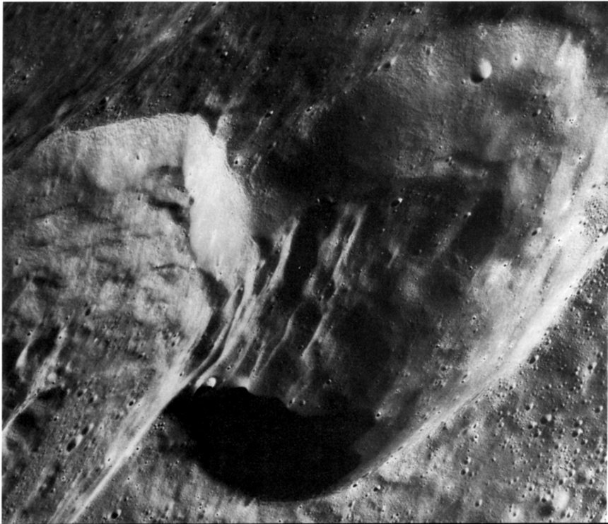
AS15-0757 (M)
FIGURE 170. - Tsiolkovsky is one of the most prominent features on the far side of the Moon. It is a 1 90-km- wide impact crater with a large, complex central peak that is offset from the apparent center of the crater. Differences in tone and texture between the central peak, the lava-flooded floor, the terraced walls, and the ejecta blanket are dramatically displayed in this oblique view. The ejecta blanket is dominated by a coarse pattern of ridges radiating outward from the crater; superposed on this pattern are many small level pools of smooth material that are much lighter than the otherwise similar smooth dark mare in the floor of Tsiolkovsky. The pools probably originated differently. They may consist of rock that was melted by the heat and pressure generated during the impact event and that flowed into depressions before it hardened.
Cratering experiments on Earth have shown that central peaks consist of bedrock that has been displaced upward by a distance equal to about one-tenth the diameter of the resulting crater. If samples could be obtained from the central peak at Tsiolkovsky, they might be rocks that were 20 km below the Moon's surface before Tsiolkovsky was created. - H.M.
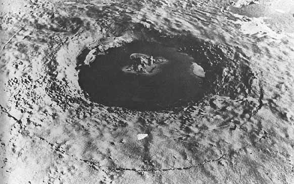
FIGURE 171. - This is clearly not another view of Tsiolkovsky, but there are some remarkable similarities between this picture and figure 170. Some of the similarities, such as viewing angle and Sun direction, resulted from screening many pictures of the same crater to duplicate viewing conditions. Other similarities are inherent in the crater-forming process. The crater above is about 100 m in diameter and 6.5 m deep. It has been intensively studied by D. J. Roddy (1968), U.S. Geological Survey, who provided the picture. It was produced in the plains of western Canada by the Canadian Defence Research Establishment as a cratering experiment. The explosive charge was a 450-Mg hemisphere of TNT resting on the ground. The site is underlain by alluvial and fluvial deposits of interlayered finegrained silt, sand, and gravel, much of which were below the local water table. The smooth, dark "floor" of the crater is water that flooded the crater immediately after it was excavated.
Similarities between the two craters include (1) complex central peaks of uplifted rock material, (2) complexly terraced walls caused by slumping along concentric faults, (3) irregular but approximately circular raised rim crests, and (4) continuous blankets of hummocky ejecta, both of which are dominated by radial depositional patterns. An obvious difference is the thin, dark, arcuate line in the near field of this picture. It is part of a zone of circumferential fractures extending around the crater. Similar fracture zones may be present around lunar craters, but, if so, they are much less obvious. - G.W.C.
AS15-1030 (M)
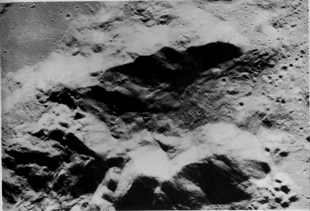
FIGURE 172. - This vertical view shows the central part of Tsiolkovsky in more detail. From the nature of the boundary between the dark mare lavas and the lighter materials at the base of the walls and in the central peak, we know that the lavas must have lapped upon and embayed the lighter materials. The relatively level areas of lighter material in the southwest and northwest parts of the floor have a distinctly different texture than the coarse blocky materials of slumped wall that surround the floor elsewhere. Finely cracked, furrowed, and hummocky, they closely resemble parts of the floor of the crater King (figs. 151 to 154). They probably consist of impact melt that solidified to form the original floor of Tsiolkovsky before it was flooded by mare lavas. - G.W.C.
AS15-9591 (P)
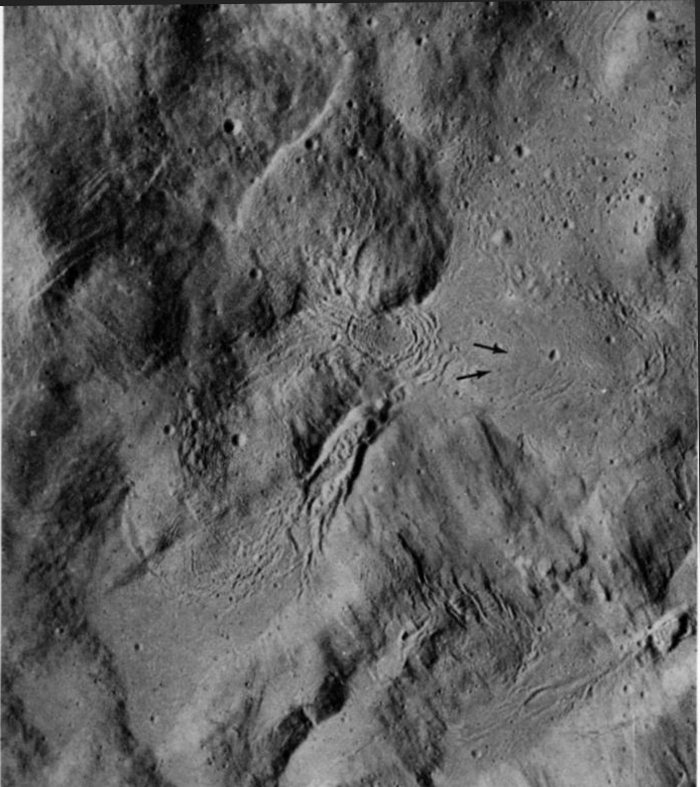
FIGURE 173. - Moderate enlargement of part of a panoramic camera frame provides greater detail of the central peak complex of Tsiolkovsky. A relatively large population of superposed craters has been preserved on level areas of the peaks (near the left-center of the photograph). In contrast, very few craters are present on steep slopes-most have been destroyed by the downslope movement of erosional debris. An intermediate population of craters on the dark mare shows that the mare surface is younger than the level areas of the peak complex but older than the freshly exposed steep slopes of the peaks. The youngest part of the mare surface is the dark, smooth area adjacent to the small angular rifle in the upper left corner. Here small craters have been almost completely filled by the flow and are barely discernible. The rifle may have served as the vent for the young lavas. - M.W.
AS15-9596 (P)
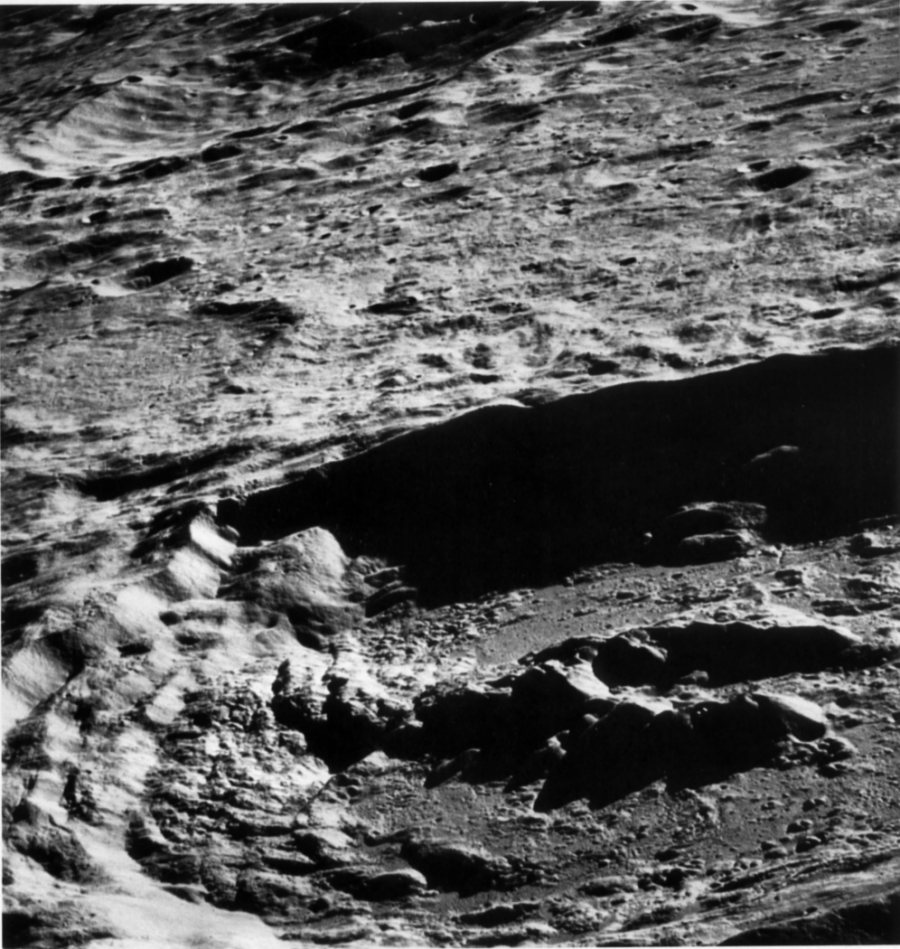
FIGURE 174. - Drastic enlargement of a panoramic camera frame provides a wealth of detail within the small area outlined in figure 172. Note the many large blocks on the slope. The largest block is about 125 m wide. Most blocks apparently originated at the discontinuous ledge near the top of the slope. Note also the fillets on the upslope side of many of the blocks. They probably consist of fine-grained debris that was trapped behind the blocks as it moved downslope. The arrows identify what appear to be two craters in the process of being destroyed by erosion. Otherwise, craters are absent on the steeply dipping slope, although numerous craters are present on the gentler slopes above. - M.W.
AS17-2608 (M)
FIGURE 175. - This apronlike expanse of striated material on the northwest flank of Tsiolkovsky is interpreted as a giant landslide. In some respects it resembles terrestrial landslide deposits. A good example is the Sherman landslide in Alaska, which was triggered by the "Good Friday" earthquake in 1964 and which covers part of the Sherman glacier. The striations apparently outline individual filaments or jets of debris like those that have been observed in experiments involving the flow of particulate matter traveling at high velocity. The flow originated at the west-facing scarp marked by an arrow. From the scarp on Tsiolkovsky's rim to the floor of the ancient crater Fermi, where the landslide came to rest, the difference in elevation is about 3000 m. The maximum distance of travel was about 50 km. - H.M.
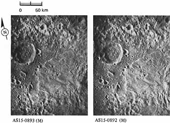
AS15-0893 (M) | AS15-0892 (M)
FIGURE 176. - The setting of the landslide is much more evident in this stereogram provided by L. J. Kosofsky. Here it is evident that the northwest rim of Tsiolkovsky is appreciably higher than the area where the landslide came to rest. The northern wall of Fermi is clearly recognizable as the very rugged south-facing slope near and parallel to the top edge of the stereogram. To those without prior knowledge of the area, Fermi's wall probably was not evident in monoscopic figure 175. - G.W.C.
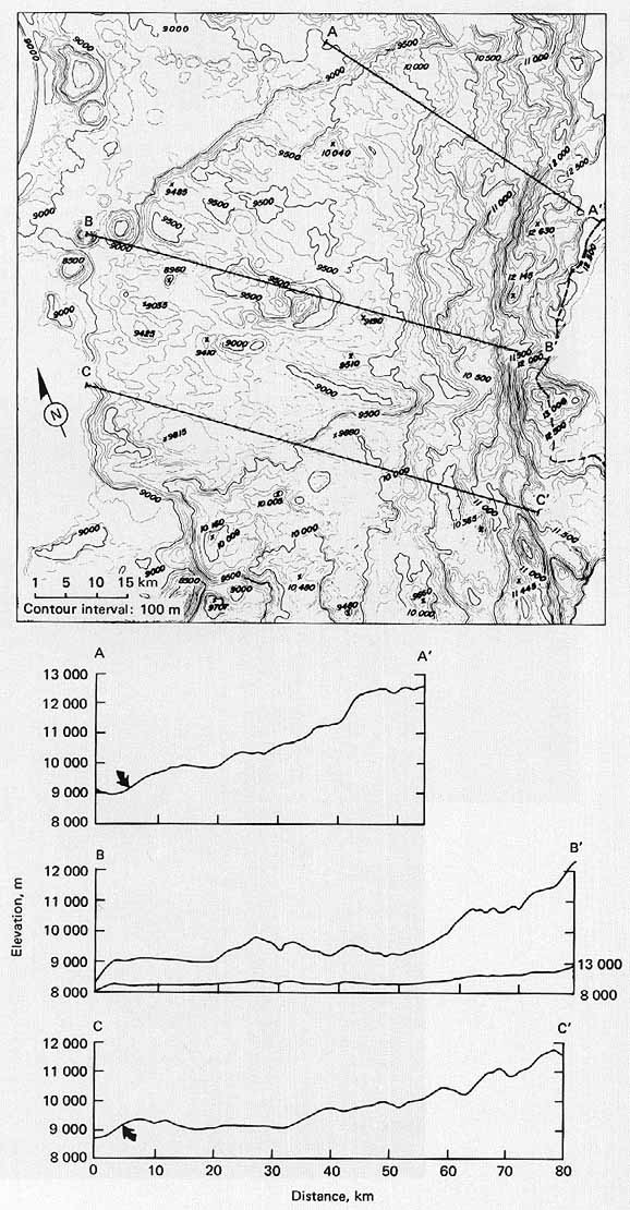
FIGURE 177. - This topographic contour map (Wu et al., 1972) was compiled from two mapping camera pictures like those in figure 176. For easier reference part of the rim crest of Tsiolkovsky has been marked with a heavy dashed line. From this map the area, the slope, and (after making some assumptions) even the volume of the landslide can be measured. The heavy straight lines across the slide locate the three topographic profiles shown below the map. Profiles are another method of portraying topographic information. On two of the profiles the lower edge or toe of the landslide has been marked with an arrow. (On the third, the lower edge has been destroyed by an impact crater.) Because the landslide is topographically a rather subtle feature, the vertical scale of the profiles has been exaggerated by a factor of 5 to show the configuration of the slide more clearly. However, for comparison, one of the profiles has also been drawn without vertical exaggeration. - G.W.C.
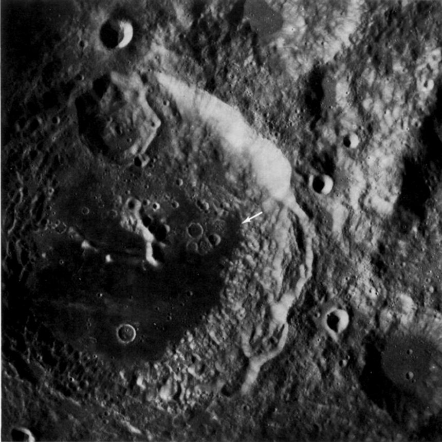
AS17-0341 (M)
FIGURE 178. - Aitken is a large crater (145 km in diameter) on the far side. Like many other large, young craters it has an outer field of secondary crater clusters and chains, an extensive inner blanket of bright ejecta, bright and rugged walls, a flat floor partly occupied by dark mare material, and a central peak complex. However, in several respects Aitken differs from other craters of comparable age and size. Its central peak has an unusual subcircular pattern, its rim crest is complexly crenulated, and its walls are best described as jumbled (El-Baz, 1973a) rather than terraced. The last two characteristics may have been caused by the shock associated with the formation of the large crater (30-km-diameter) on Aitken's north wall. The shock may well have destroyed the preexisting terraces and caused the additional slumping that gives the rim crest its crenulated appearance. Many interesting features are visible on Aitken's floor. Among them are some unusual ridges (arrow), which were described earlier (fig. 84), and several very unusual craters or depressions, some of which may be the sources of the mare fill (El-Baz, 1973a). - G.W.C.
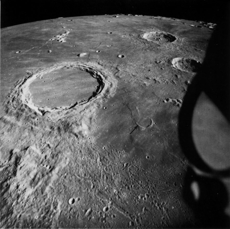
AS15-1541 (M)
FIGURE 179. - The ejecta blanket and secondary impact craters of the mare-filled crater Archimedes (80 km in diameter) are visible on the terrain toward the viewer (south) but not on the mare surface to the crater's left and right. Yet at one time ejecta like that to the south must have completely surrounded Archimedes because similar ejecta surrounds craters such as Aristillus (upper right). Thus, the mare lavas, in addition to filling the interior of Archimedes, obviously have covered the eastern and western parts of the ejecta. In turn, ejecta from Archimedes has covered materials of the Imbrium basin like the rugged hills in the lower left of the picture. These stratigraphic relations prove that time elapsed between formation of the Imbrium basin and its filling by mare-time enough for impacts to create Archimedes, the deeply flooded crater to its right (arrow), and similar "Imbrian-age" craters elsewhere, as was pointed out by Eugene Shoemaker in 1962.
Archimedes is the first large crater described in this chapter that has no visible central peak complex. Presumably the complex exists but has been completely inundated by the mare. - D.E.W.
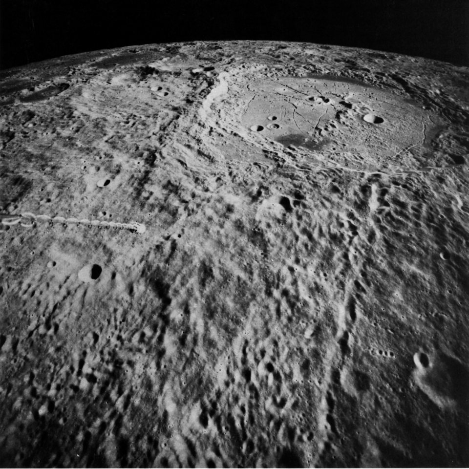
AS15-2510 (M)
FIGURE 180. - The crater Humboldt, on the east limb of the Moon, as seen from Earth, is 200 km across, a little larger than Tsiolkovsky. This view by the Apollo 15 mapping camera looks southward across Humboldt's ejecta blanket and into the crater. Irregular secondary craters partly covered by the ejecta are in the foreground, and a long chain of secondaries extends from Humboldt's rim to the foreground. Humboldt is one of the largest craters known to have a prominent central peak. If the crater is like terrestrial impact structures, the peak may expose rock uplifted about 10 percent of the crater's width, on the order of 20 km from beneath the crater floor. This would be an exciting find for future astronauts. A spider web of cracks on the crater floor suggested to R. B. Baldwin (1968) that the floor was bowed up in the middle. Later, dark mare lavas flooded low areas in the outer part of the floor and covered the cracks. A peculiar "bull's eye" double crater on the crater floor has several counterparts elsewhere on the Moon. The origin of these double craters is a continuing puzzle. - K.A.H.
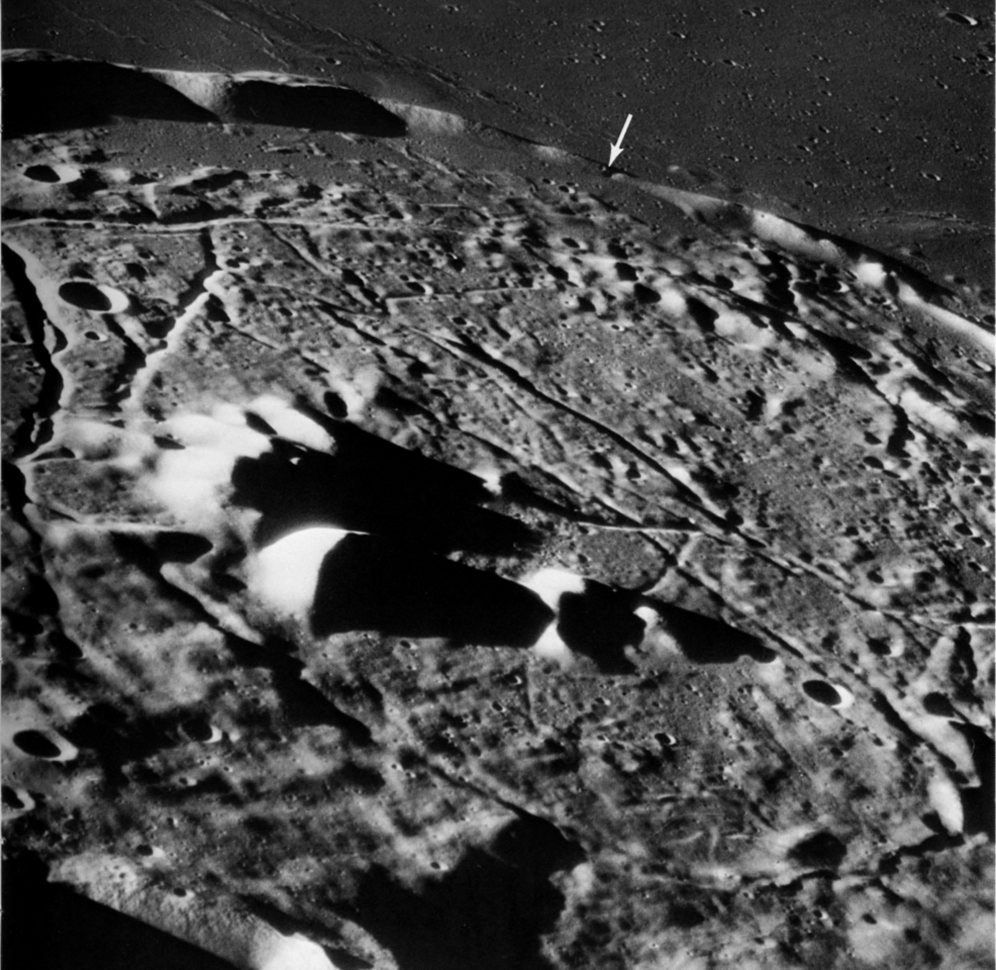
AS16-120-19295 (H)
FIGURE 181. - This view into the shallow crater Gassendi shows another strongly fractured crater floor. Gassendi is about 110 km wide. Dark mare lavas in the distance embay the rim and a little of the interior of Gassendi. They may have entered the crater through the narrow gap partly in shadow below the arrow. Most craters that have fractured floors are near areas of mare flooding. This suggests that the fracturing is a consequence of volcanic activity. An area next to the central peaks of Gassendi was the runnerup choice for a landing site for Apollo 17. - K.A.H.
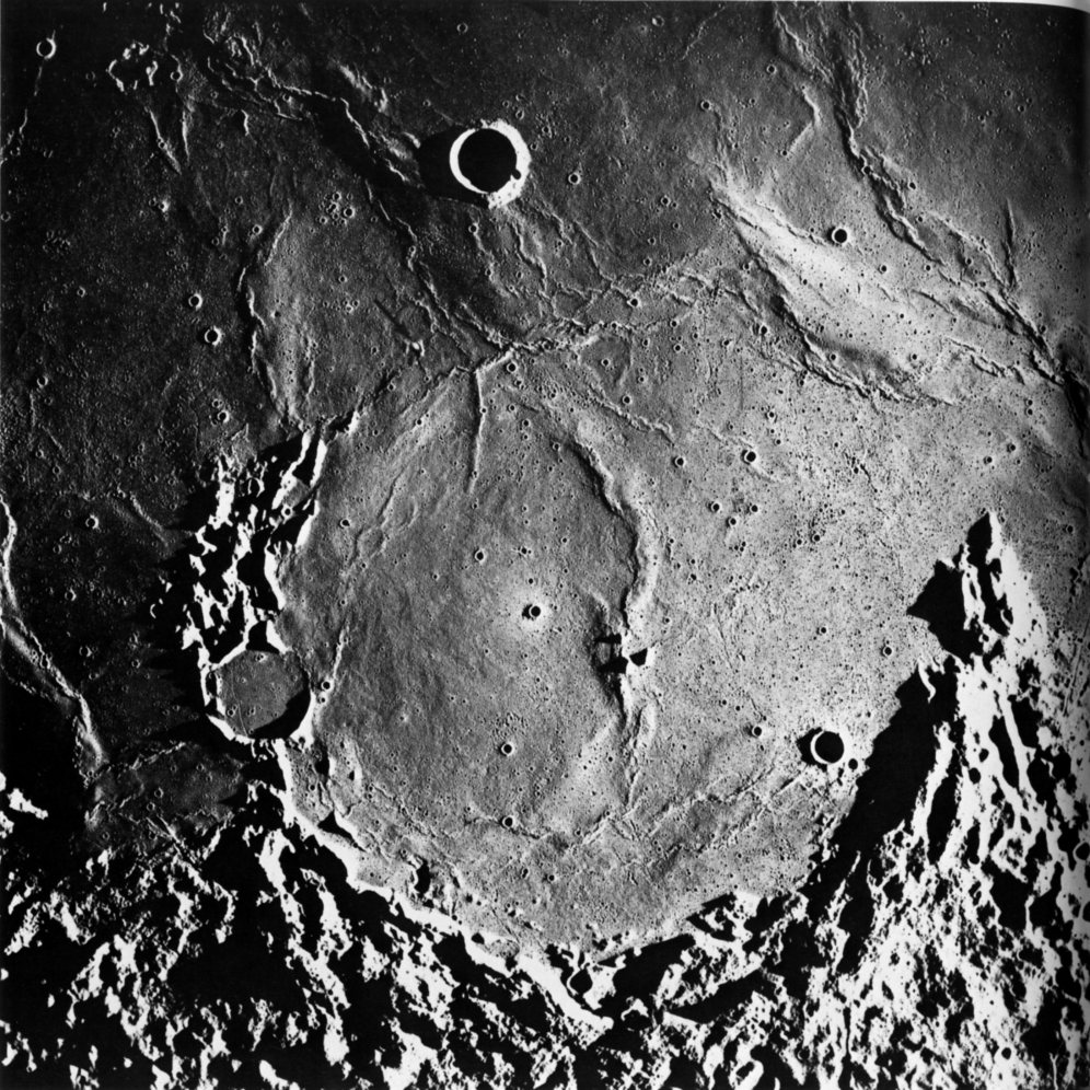
AS16-2995 (M)
FIGURE 182. - This arcuate structure is Letronne. It straddles the boundary between southern Oceanus Procellarum and the southern highlands. From "horn to horn" it is about 115 km wide. Astronomers have long recognized Letronne as a crater and geologists also interpret it as a crater because those parts preserved have much in common with better-preserved craters. The preserved crater elements include a large segment of a raised rim, a partly preserved blanket of ejecta occupying depressions along the lower edge of the picture, and the tips of three centrally located peaks that presumably represent the top of a buried central peak complex. The largest and steepest slopes along the rim face inward and probably define the wall of Letronne. The northern one-third of the rim and wall has been almost completely buried by the mare lavas of Oceanus Procellarum. An isolated small hill (arrow) and the crudely arcuate band of mare ridges east of the hill mark the approximate position of the buried rim. The abrupt disappearance of the rim beneath Oceanus Procellarum suggests faulting, but vertical movement without faulting is also possible; this part of Procellarum may have been tilted downward or the adjacent highlands upward. - G.W.C.
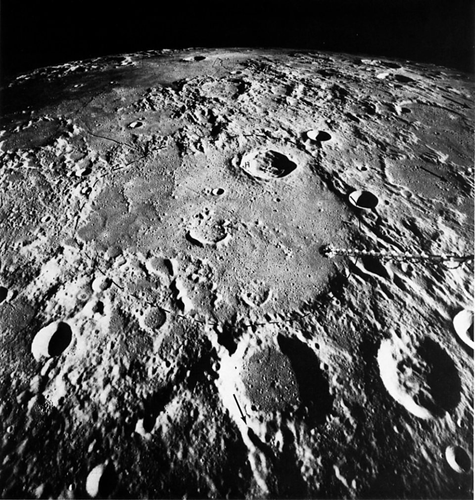
AS16-0839 (M)
FIGURE 183. - The very old crater Hipparchus has been nearly obliterated during eons of lunar change. Except for the circular pattern of subdued mountains (dashed line) that surround most of it, Hipparchus would not be recognizable. It is about 150 km wide. Beyond it near the horizon at the left is Sinus Medii, the smooth dark- surfaced area that lies at the center of the Moon when seen from Earth. Part of the rim of Hipparchus is modified by "Imbrium sculpture," the pattern of ridges and grooves radial to Mare Imbrium, which affects the lunar surface for more than 1000 km from Imbrium. The four arrows show how the pattern radiates outward across this part of the Moon. (The Imbrium basin lies beyond the left horizon.) Craters and hills have been formed in the floor of Hipparchus and subsequently have been partially inundated by marelike plains deposits. The ejecta blanket of the much younger crater Horrocks (identified by H) is, in turn, spread over the marelike filling. - M.C.M.