2. The Uses of Space
In contrast to the routine two way traffic made possible by the Shuttle, every payload sent into orbit for the first two decades of the space era- every bug, plant, and animal; every man, woman (one, a Russian), and automated laboratory-rode on the nose of a one-trip rocket that was discarded after a working lifetime measured in minutes. However costly, those pioneering ventures into space sent back startling news of the universe and brought countless changes for the better in the ways we live: changes in the economy, in health and safety, in science and technology, in education, in the protection and use of natural resources, in national defense and international cooperation.
The first was a revolution in communication.
In the middle of the night of July 10, 1962, television relay stations at Goonhilly Downs, Cornwall, and Pleumeur-Bodou, Brittany, picked up a black-and-white picture of an American flag flapping in the breeze to the accompaniment of the Star Spangled Banner. The program was a demonstration being transmitted skyward from a huge horn-shaped antenna in Maine to a glistening new Earth satellite, Telstar I, and down to a receiving dish in New Jersey for distribution to U.S. viewers. Though not intended, the signal also was being bounced from Telstar across the Atlantic to England and France.
Next day the experimental satellite relayed the first TV pictures westward from Europe, black-and-whites from both France and England, and within a week the first in color. Before the month was out, mass audiences on both sides of the Atlantic watched with awe the first international exchange of live TV. Viewers in Europe saw the Statue of Liberty, a baseball game between the Phillies and the Cubs in Chicago, a press conference by President Kennedy, buffalo roaming the South Dakota plains, the Mormon Tabernacle Choir singing from Mount Rushmore. Americans, in turn, got glimpses of Big Ben from one of London’s Thames bridges, the Coliseum in Rome, the Louvre in Paris, the Sistine Chapel in Vatican City, Sicilian fishermen reefing their nets, reindeer roaming near the Arctic Circle in Norway.
The trouble with Telstar (and its early successors) was that it could be used only when its relatively low-altitude orbit of 945 by 5600 kilometers (580 by 3500 miles) brought it within range of both U.S. and European ground stations for a few minutes during each 158-minute circuit of the globe. This problem was solved the next year by the Syncoms, whose speed in circular orbits of 35,800 kilometers (22,300 miles) above the equator kept pace with Earth’s rotation, so that the spacecraft seemed to hover stationary over the same place on Earth: hence the description as geostationary or geosynchronous. Thus one satellite could be used continuously by ground stations within its view, which covered almost a third of the globe. The Syncoms set the pattern for more than fifty commercial and research communications satellites launched during the next fifteen years.
Before the end of the 1970s a global communications satellite system, Intelsat, was being used by nearly 100 countries-from Afghanistan to Zambia—to exchange TV news, telephone calls, and business data. It was continuously expanded to meet a growing demand for services. More than a billion people, one out of every four on Earth, could see a major event as it happened: “live via satellite.” Worldwide investment in communications satellite systems was more than $1 billion, and revenues were more than $200 million a year. Despite inflation, international telephone calls were cheaper than when the first Intelsat began service in 1965.
In 1972 Canada launched the first space relay station whose beam could be focused to fall within a single country. It now has three such domestic communications satellites and a network of fifty ground stations serving the entire country, including far northern settlements formerly reached only by unreliable radio. Four companies soon were operating domestic communications satellites in the United States, and a dozen other countries had them. In some developing nations it was easier to make a phone call to a city a thousand miles away than to the next town.
Meantime, a series of NASA research satellites demonstrated how space communications could be useful for such varied purposes as transmitting educational programs and medical instructions directly to isolated villages via low-cost local receiving stations; providing emergency communications in disaster areas; searching for lost aircraft and disabled ships and guiding rescuers to them; exchanging classroom lectures between colleges thousands of miles apart; directing air traffic far at sea; and bringing businessmen in different cities face-to-face electronically for two-way conferences, saving travel time and fuel.
Weather observation from orbit quickly followed space communications into everyday operational service to millions of people around the world. Since 1966 the entire Earth has been photographed daily from space, and no tropical storm has escaped detection and tracking. Thousands of lives and billions of dollars there is no way to count them precisely have been saved by improved forecasts, early storm and food warnings, reports to shippers on wind conditions and iceberg hazards, advice to farmers on when to plant, irrigate, fertilize, spread insecticide.
One kind of meteorological satellite circles the globe on north-south tracks, looking down as Earth turns underneath. Its reports are assembled by computers in the United States to make a complete picture of worldwide weather conditions every twelve hours and also are transmitted directly to hundreds of inexpensive local stations in scores of countries as the spacecraft passes overhead. A second kind of weather satellite, in geosynchronous orbit, appears to stand still in space, keeping continuous watch on a large area—two of them cover all of North and South America and the adjacent oceans. They return a fresh picture every half hour, day and night, to produce, among other uses, the time-lapse movie strips now commonly seen on television weather programs.
Besides cloud cover and movements, weather satellites report air and sea-surface temperatures, wind speeds, atmospheric pressure and moisture content, rainfall, snow cover, and ice fields. Some collect data from untended sensors and gauges in remote areas, at sea, and on balloons. The pictures and measurements are used not only for routine local, regional, national, hemispheric, and global forecasts but also to track dangerous fast-moving storms: hurricanes and short-lived severe thunderstorms that may set off tornadoes.
In the mid-1970s observations of large wheat-growing areas of the world from both weather and natural-resources survey satellites were combined with surface information to measure acreage and estimate yields in a successful demonstration that crop forecasts could be improved with data from space. Information was gathered not only over the United States but also over Canada, Russia, China, India, Australia, Brazil, and Argentina. Obviously, early production estimates made regularly in this way could be of significant help in planning food distribution and avoiding the market shocks of unforeseen shortages and bumper harvests.
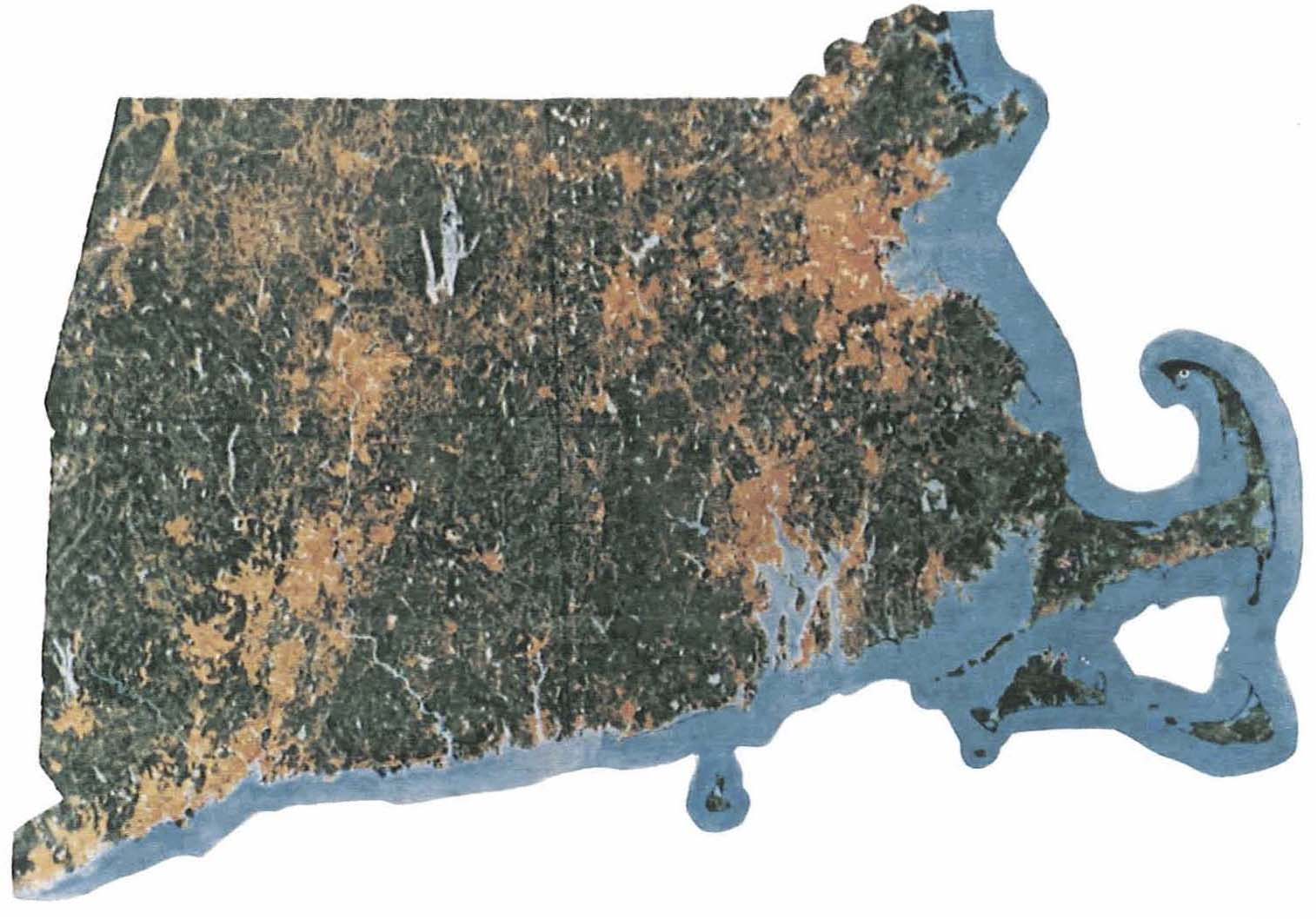
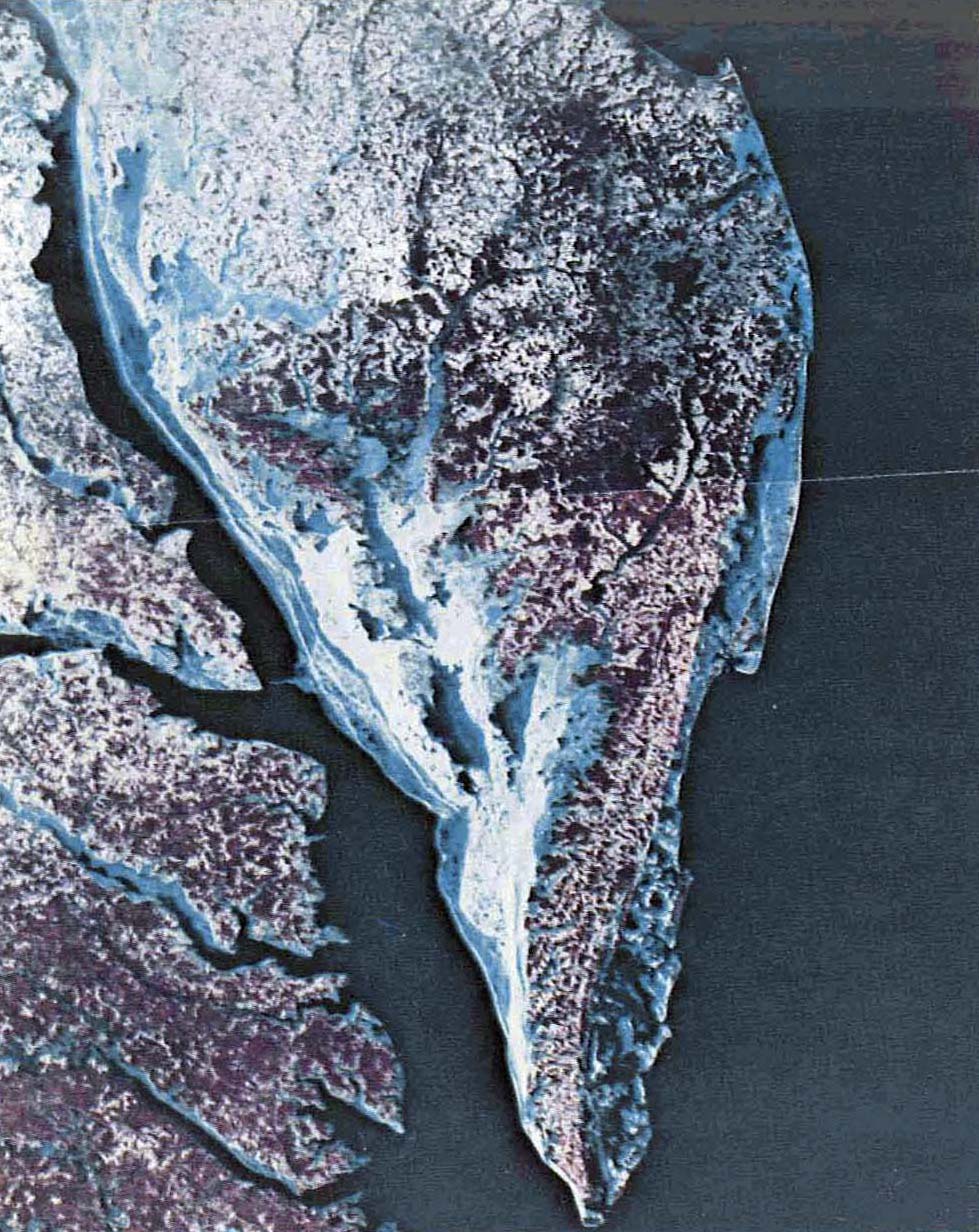
Pictures and computer data from a series of Earth resources survey satellites and also from the manned Skylab space station were used in dozens of ways in the 1970s to help federal agencies, state and local governments, regional planning authorities, private industry, and foreign countries manage limited natural resources and monitor the threatened environment
Examples:
- Mapping mountain snow cover to forecast spring runoff available for irrigation and power generation;
- Detecting oil slicks at sea;
- Compiling a global atlas of glaciers;
- Making inventories of standing timber and grasslands;
- Monitoring offshore dumping of sewage sludge and industrial wastes;
- Mapping floods to help in evaluating damage and planning relief;
- Checking on the environmental effects of developing new energy sources, such as strip mining;
- Detecting potential earthquake zones as an aid in planning future construction;
- Measuring forest-fire damage and the extent of clear-cutting and gypsy-moth defoliation;
- Tracing air pollution and lake silting;
- Mapping land-use changes as an aid to wiser urban planning;
- Counting and measuring the area of dams and lakes;
- Watching glaciers for signs of rapid movements that could dam up melt waters and later cause floods;
- Mapping uncharted coastal shoals that could endanger shipping;
- Making and updating other maps and navigation charts;
- Making low-cost soil surveys and geologic maps.
The savings, compared with the cost of aerial surveying, made mapping from space attractive. New Jersey, for instance, saved $2.8 million by using satellite images to calculate beach erosion. Another state found that fourteen space pictures and one and a half man-years of work, costing $75,000, could produce a land-use map that would have taken 20000 aircraft photos, forty-four man-years, and $1.7 million.
Half a dozen foreign countries built their own ground stations for receiving transmissions directly from the Earth survey satellites when overhead. All the pictures and data were put on sale to anyone anywhere by the U.S. Department of Interior. To no one’s surprise, the biggest buyers were oil and mining companies, looking for likely new places to drill and dig; orders were strong for information on the vast unexplored reaches of Alaska. Clearly, monitoring Earth’s shrinking natural resources from orbit was the next area of space activity ripe for routine use. Government agencies and private groups began discussions of how an operational service, like those of communications and weather satellites, should be organized and managed and the information distributed.
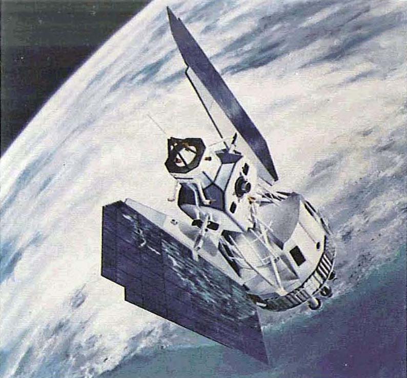
Other Earth-oriented satellites demonstrated space-based navigation for ships and planes; made precise measurements of the globe’s size, shape, bumps, and hollows; detected slight movements of large land masses-tectonic plates—in search of the causes of earthquakes; collected data on ocean surface winds, currents, and waves; measured the daily heating and cooling of rocks for clues to oil and mineral deposits; mapped worldwide air pollution; and—in a demonstration—tracked an arctic explorer and his dog sled across the North Pole. The military services put up their own satellites for rapid global communication and reconnaissance to verify arms-control agreements.
This quick sketch of American achievements in space during the 1960s and ’70s has emphasized activities leading to immediate benefits in daily living. Much of the money, man-power, and ingenuity spent on the nation’s space program, however, during the years of reliance on expendable launch vehicles, before the coming of the reusable Shuttle, was devoted to scientific exploration of the solar system and the universe beyond and to demonstrating that man can live and work in space.
The results were spectacular and potentially rewarding.
Increasingly complex automated laboratories, from the first simple Explorers to the almost-human Vikings, mapped interplanetary radiation and magnetic fields; analyzed the turbulent Sun from above Earth’s obscuring blanket of air; photographed the entire Moon from lunar orbit, then landed gently on its cratered surface; observed Venus, Mercury, Mars, and Jupiter closeup and sent back magnificent pictures; tested the Martian soil for signs of past or present life; and probed the heavy atmosphere of Venus down to the planet’s broiling surface. Orbiting observatories extended enormously the depth and breadth of astronomers vision and discovered mysterious energy sources at incredible distances. New knowledge of other worlds will lead to better understanding of our own, as observations of other planets’ atmospheres are already opening fresh insights into the mechanisms of Earth’s weather.
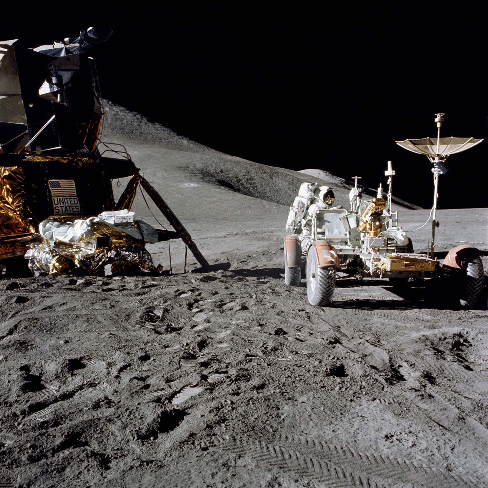
A succession of twenty-eight U.S. manned flights from Mercury through Apollo-Soyuz proved that people can perform useful tasks together in space and survive long periods of weightlessness without serious or lasting harm. The Gemini flights worked out the techniques of maneuvering in orbit. Apollo’s heroes, as all the world knows, explored the Moon first-hand, gathered samples of its soil and rocks for analysis back home, and set up science stations that continued to radio data long after the last men left. Three Skylab crews produced useful medical knowledge about the body’s reaction to stress, studied the Sun with a large manned telescope and Earth with multispectral scanners sharper than the human eye, and demonstrated the possibility of manufacturing in zero-gravity new and better products that cannot be made on the ground.
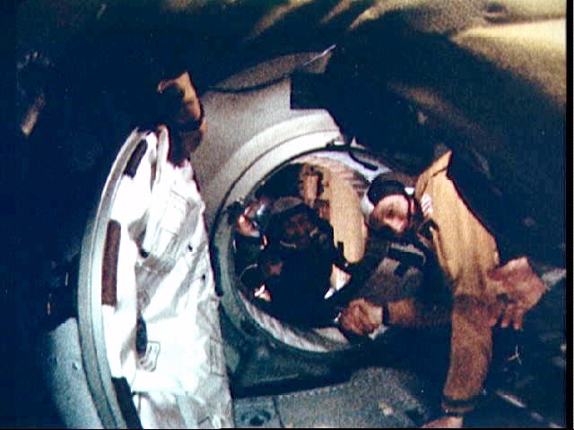
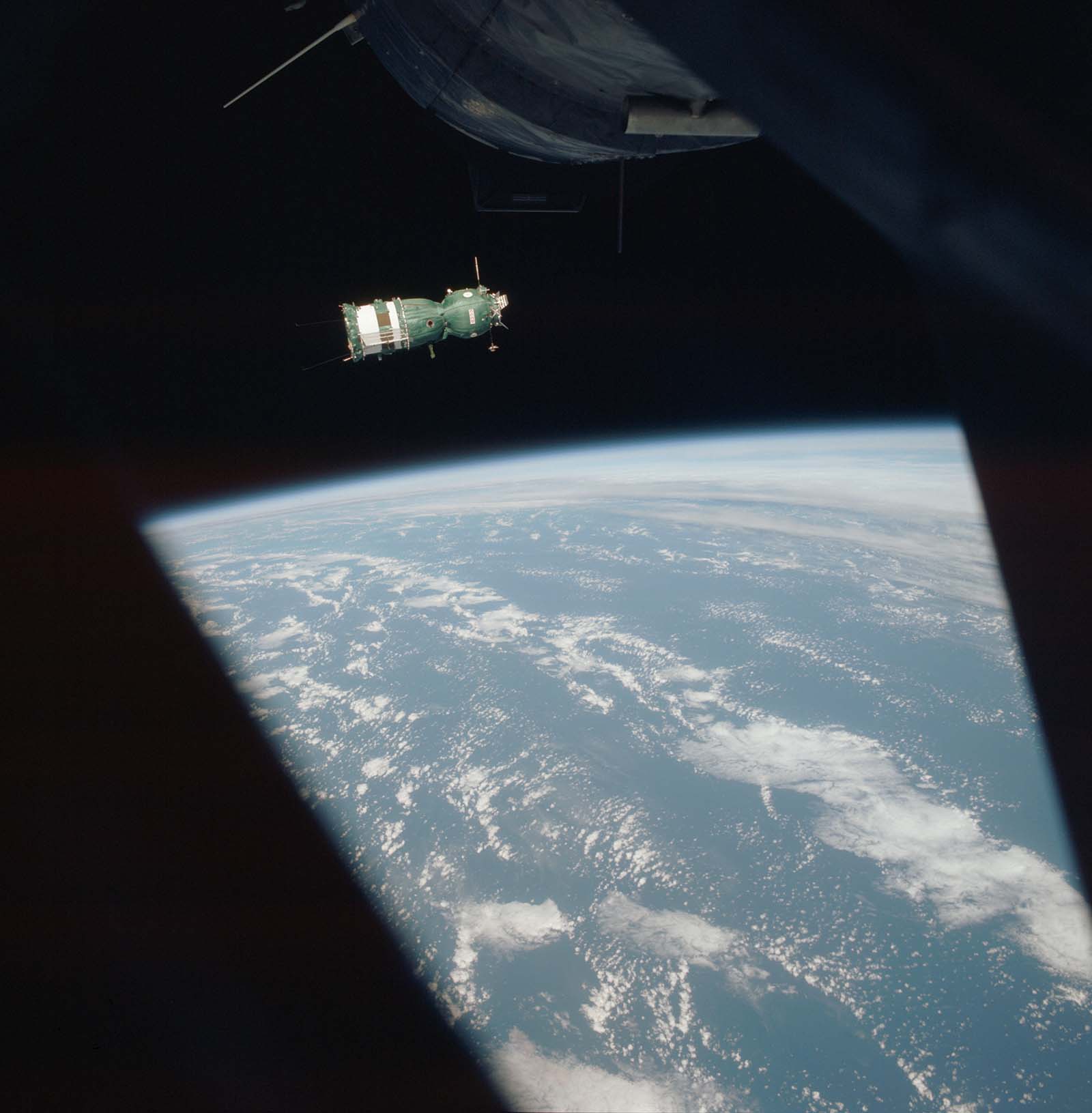
The handshake in orbit by an astronaut of the last Apollo and a cosmonaut of Russia’s Soyuz symbolized more than a promise of future international cooperation in space. America’s program of the 1960s and ’70s was conducted in the open and the results shared with all the world. NASA launched scientific and communications satellites for a dozen nations. U.S. spacecraft carried experiments by scientists of twice that many countries, including the Soviet Union. Two hundred fifty foreign researchers from twenty-one nations participated in Skylab investigations; 600 scientific and technical groups in more than 130 countries used images from the Landsat natural-resources satellites. In a year-long demonstration a U.S. experimental communications satellite transmitted educational television programs to 5000 villages in India where most people had never seen a TV picture. As the two decades ended, Canada and members of the European Space Agency were at work on major roles in the Shuttle-based Space Transportation System.
Meeting the time schedules, safety requirements, and performance goals of space exploration stretched and pushed American technology in all directions. Yankee ingenuity had to come up with strong new alloys and composites, lubricants that wouldn’t evaporate in a vacuum, long-lasting batteries, tiny yet highly reliable electronic parts, ultrasensitive fire detectors, more efficient solar-power panels, compact computers, foods that keep fresh without refrigeration, high resolution cameras, low-power communications equipment, improved welding and wiring techniques, miniature sensors, lightweight pumps, tough fireproof fabrics. The list could go on for pages. Thousands of innovations in materials, devices, and procedures were described in NASA publications and cataloged in computer-tape libraries open to U.S. industry. Hundreds of them, called spinoffs, soon were turning up in commercial uses and medical products from the silvery dome of the Detroit Lions’ new stadium to rechargeable heart pacemakers.
Spending on space projects, including the Shuttle transportation system, stimulated the economy both directly and indirectly. The dollars were not shot off into orbit when they might better have been spent on Earth, as some critics liked to say, but went mainly to pay workers more than 400,000 at the peak of the Apollo program in every state. And because aerospace wages were relatively high, much of the money tended to be passed along promptly, creating more jobs. Moreover, as economists have long known, technological advancement is the primary source of higher productivity and economic growth. High technology industries also contribute more than others to the nation’s export trade, helping to offset imports of raw materials, minerals, and fuels.
But perhaps the greatest gift from the space pioneers to men, women, and children of all nations was a new view of their home planet. President Carter, at a ceremony in which he awarded Congressional Space Medals to outstanding astronauts, expressed it this way:
We went to the Moon. in part. as a matter of national pride. But when we got there, we discovered something very interesting. Through the eyes of the cameras of the astronauts, we looked back at the Earth, above the strange horizon of the Moon in a pitch black sky; we saw our own world as a single delicate globe of swirling blue and white, green, brown. From the perspective of space our planet has no national boundaries. It is very beautiful, but it is also very fragile. It is our special responsibility to the human race to preserve it. Of all the things we have learned from our exploration of space, none has been more important than this perception of the essential unity of our world.